IMAGES TAKEN NEAR TO
School Lane, AYLESBURY, HP18 9PT
Introduction
This page details the photographs taken nearby to School Lane, HP18 9PT by members of the Geograph project.
The Geograph project started in 2005 with the aim of publishing, organising and preserving representative images for every square kilometre of Great Britain, Ireland and the Isle of Man.

There are currently over 7.5m images from over14,400 individuals and you can help contribute to the project by visiting https://www.geograph.org.uk
Image Map
Images are licensed for reuse under creativecommons.org/licenses/by-sa/2.0
Notes
- Clicking on the map will re-center to the selected point.
- The higher the marker number, the further away the image location is from the centre of the postcode.
Image Listing (50 Images Found)
Images are licensed for reuse under creativecommons.org/licenses/by-sa/2.0
Image
Details
Distance
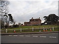
3
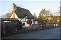
House on The Turnpike, Oakley
From Bicester Road
Image: © David Howard
Taken: 20 Mar 2016
0.04 miles
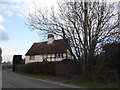
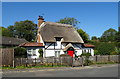
4
Thatched cottage in Oakley
A change from the many undistinguished residential properties in Oakley.
Image: © Bill Boaden
Taken: 24 Dec 2022
0.08 miles
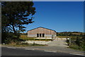
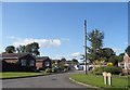
7
Manor Road, Oakley
Junction with the B4011.
Image: © JThomas
Taken: 21 Sep 2019
0.10 miles
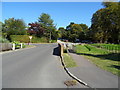
8
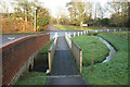
Footpath over a small stream in Oakley
The stream flows from Brill to the River Thame, but I have been unable to find a name for it.
Image: © Bill Boaden
Taken: 24 Dec 2022
0.10 miles
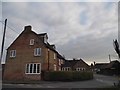
9
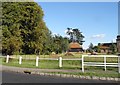
Garden by Manor Road, Oakley
Those anthills are pretty impressive
Image: © David Howard
Taken: 10 Aug 2017
0.10 miles