IMAGES TAKEN NEAR TO
Piddington Road, AYLESBURY, HP18 9PQ
Introduction
This page details the photographs taken nearby to Piddington Road, HP18 9PQ by members of the Geograph project.
The Geograph project started in 2005 with the aim of publishing, organising and preserving representative images for every square kilometre of Great Britain, Ireland and the Isle of Man.

There are currently over 7.5m images from over14,400 individuals and you can help contribute to the project by visiting https://www.geograph.org.uk
Image Map
Images are licensed for reuse under creativecommons.org/licenses/by-sa/2.0
Notes
- Clicking on the map will re-center to the selected point.
- The higher the marker number, the further away the image location is from the centre of the postcode.
Image Listing (10 Images Found)
Images are licensed for reuse under creativecommons.org/licenses/by-sa/2.0
Image
Details
Distance
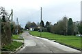
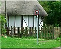
2
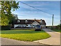
Cottage on Piddington Road, Ludgershall
Image: © David Howard
Taken: 10 Oct 2021
0.06 miles
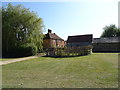
3
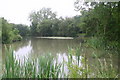
New Pond Ludgershall
New Pond Ludgershall by the Bernwood Way
Image: © Shaun Ferguson
Taken: 8 Jun 2007
0.09 miles
6
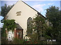
The Wesleyan Methodist Chapel, Ludgershall
Image: © Dennis Troughton
Taken: 17 Sep 2005
0.22 miles
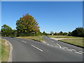
10
Public Footpath sign and speed restriction
Image: © michael
Taken: 19 Jun 2011
0.25 miles