IMAGES TAKEN NEAR TO
Dorton, AYLESBURY, HP18 9NQ
Introduction
This page details the photographs taken nearby to HP18 9NQ by members of the Geograph project.
The Geograph project started in 2005 with the aim of publishing, organising and preserving representative images for every square kilometre of Great Britain, Ireland and the Isle of Man.

There are currently over 7.5m images from over14,400 individuals and you can help contribute to the project by visiting https://www.geograph.org.uk
Image Map
Images are licensed for reuse under creativecommons.org/licenses/by-sa/2.0
Notes
- Clicking on the map will re-center to the selected point.
- The higher the marker number, the further away the image location is from the centre of the postcode.
Image Listing (26 Images Found)
Images are licensed for reuse under creativecommons.org/licenses/by-sa/2.0
Image
Details
Distance
1
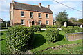
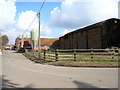
Brook farmhouse
Most of Brook Farm is in Image but the farmhouse is primarily in this square. The eponymous brook is in the foreground. The telephone wires make it impossible to get an unobstructed photo.
Image: © Graham Horn
Taken: 10 Mar 2012
0.05 miles
2
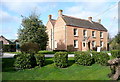
Brook farmhouse
Most of Brook Farm is in Image but the farmhouse is primarily in this square. Note the double roof.
Image: © Graham Horn
Taken: 10 Mar 2012
0.05 miles
3
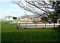
Brook Farm
The eponymous brook runs in the foreground, with a public footpath on its southern side (my side).
Image: © Graham Horn
Taken: 10 Mar 2012
0.06 miles
4
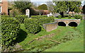
Culvert at Dorton
This culvert takes a brook under the main road through the village. The brook seems as though it rarely holds more water than this. The brickwork and that stick are dry.
Image: © Graham Horn
Taken: 10 Mar 2012
0.06 miles
5
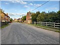
Dorton
Looking northwest from the sharp bend on the road through the village.
Image: © Andrew Smith
Taken: 4 Mar 2006
0.06 miles
6
The centre of Dorton
In fact it's nearly all of Dorton
Image: © David Howard
Taken: 10 Oct 2021
0.08 miles
7

Hill Farm, Dorton
Pretty much the same as Andrew's 2006 view Image except with a bit less hay and a bit more ugly tank.
Image: © Des Blenkinsopp
Taken: 10 Mar 2015
0.08 miles
8
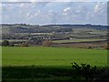
Dorton seen from Ashendon
The ground rises up behind the village towards Brill
Image: © Bikeboy
Taken: 1 Nov 2014
0.10 miles
9
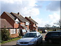
Modern houses and farmland, Dorton
Looking east from the main road through the village.
Image: © Andrew Smith
Taken: 4 Mar 2006
0.10 miles
10
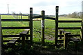
Take your pick
Cleverly, the field boundary comes to the field edge here and the two footpaths, one in each field, each have a separate stile. We had come along the left-hand one but looking at the worn grass it looks as though the other might be more popular. Both will get you to Brill.
Image: © Graham Horn
Taken: 10 Mar 2012
0.10 miles