IMAGES TAKEN NEAR TO
Dorton, AYLESBURY, HP18 9NE
Introduction
This page details the photographs taken nearby to HP18 9NE by members of the Geograph project.
The Geograph project started in 2005 with the aim of publishing, organising and preserving representative images for every square kilometre of Great Britain, Ireland and the Isle of Man.

There are currently over 7.5m images from over14,400 individuals and you can help contribute to the project by visiting https://www.geograph.org.uk
Image Map
Images are licensed for reuse under creativecommons.org/licenses/by-sa/2.0
Notes
- Clicking on the map will re-center to the selected point.
- The higher the marker number, the further away the image location is from the centre of the postcode.
Image Listing (6 Images Found)
Images are licensed for reuse under creativecommons.org/licenses/by-sa/2.0
Image
Details
Distance
1
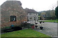
Spa Farm
The residential buildings of the farm. The farmhouse is made from local, pale stone, but the other building is brick. Taken from the public footpath that runs to the north of the buildings.
Image: © Graham Horn
Taken: 10 Mar 2012
0.01 miles
2
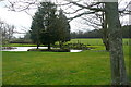
Pond at Spa Farm
The farm has a lovely setting, with a man-made pond and extensive views beyond. This is taken from the public footpath that runs to the north of the buildings.
Image: © Graham Horn
Taken: 10 Mar 2012
0.05 miles
3
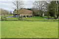
Spa Farm
The farm has a lovely setting, with a man-made pond and extensive views beyond. The footpath runs to the left of the barn.
Image: © Graham Horn
Taken: 10 Mar 2012
0.05 miles
4
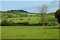
Pasture, Dorton
Dorton Hill rises in the background above fields at Spa Farm.
Image: © Andrew Smith
Taken: 20 May 2023
0.12 miles
5
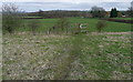
Footpath towards Spa Farm
I don't know what has been in this field but there were tough roots everywhere, just at foot-tripping height. The next field was pasture, much better.
Image: © Graham Horn
Taken: 10 Mar 2012
0.15 miles
6
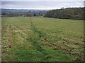
Footpath to Spa Farm
Footpath heads down the hill towards Spa Farm
Image: © Shaun Ferguson
Taken: 31 Oct 2009
0.20 miles