IMAGES TAKEN NEAR TO
Chilton, AYLESBURY, HP18 9LS
Introduction
This page details the photographs taken nearby to HP18 9LS by members of the Geograph project.
The Geograph project started in 2005 with the aim of publishing, organising and preserving representative images for every square kilometre of Great Britain, Ireland and the Isle of Man.

There are currently over 7.5m images from over14,400 individuals and you can help contribute to the project by visiting https://www.geograph.org.uk
Image Map
Images are licensed for reuse under creativecommons.org/licenses/by-sa/2.0
Notes
- Clicking on the map will re-center to the selected point.
- The higher the marker number, the further away the image location is from the centre of the postcode.
Image Listing (24 Images Found)
Images are licensed for reuse under creativecommons.org/licenses/by-sa/2.0
Image
Details
Distance
1
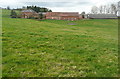
Home Farm
'Home' in the sense of being the farm belonging to, and providing for, the estate, Chilton Manor. The manor is now a nursing home so I expect the farm is either run privately or there is a tenant farmer, but production is probably not now linked to the needs of an estate.
Image: © Graham Horn
Taken: 10 Mar 2012
0.04 miles
2
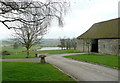
Townhill Farm
Look past the farm entrance and a significant stone barn towards the artificial lake of Chilton House.
Image: © Graham Horn
Taken: 10 Mar 2012
0.13 miles
3
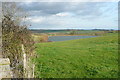
Towards Chilton Lake
The lake, or pond, is in the nest square Image It is quite new, indeed it is not shown on my 1999 1:25,000 map. But it seems to be associated with Chilton House, now a nursing home. The surrounding area is all grassland.
Image: © Graham Horn
Taken: 10 Mar 2012
0.13 miles
4
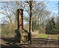
Lonely Chimney
This chimney stack and fireplace is beside the footpath near Chilton House. I guess it must have had a building attached to it at some time.
Image: © Des Blenkinsopp
Taken: 10 Mar 2015
0.14 miles
5
Townhill, Chilton
Grade 2 listed, 17th century with additions http://www.britishlistedbuildings.co.uk/en-42992-townhill-chilton-buckinghamshire
Originally listed as Townhill Farm.
Image: © Des Blenkinsopp
Taken: 10 Mar 2015
0.15 miles
6
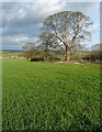
Arable land near Home Farm
This field has been left to grass this year, probably for silage use.
Image: © Graham Horn
Taken: 10 Mar 2012
0.16 miles
7
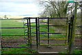
Kissing gate at Chilton House
This gate takes the footpath across the fields of Home Farm, with Chilton Lake ahead in the next square.
Image: © Graham Horn
Taken: 10 Mar 2012
0.16 miles
8
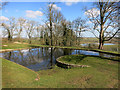
Unusual Pond, Chilton House
Just the place for an ornamental pond, in front of the house overlooking a valley.
But the twin slipways suggest there was some other purpose in designing it this way.
Pure guesswork here, but might it have been for washing animals? You could ride your horse round this to get the mud off his feet after a day in the fields.
Or perhaps His Lordship liked to come out of his house and go for a paddle.
Image: © Des Blenkinsopp
Taken: 10 Mar 2015
0.16 miles
9
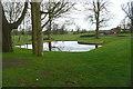
Pond at Chilton House
The pond has an unusual shape. It is clearly artificial but also seems to have a slipway in and a deliberate half-moon shape. Can anyone shed any light on the reason?
Image: © Graham Horn
Taken: 10 Mar 2012
0.16 miles
10
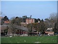
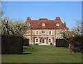
Chilton House
Built in C16 and altered in 1740. See http://www.britishlistedbuildings.co.uk/en-42998-chilton-house-including-forecourt-walls-g for entry in British Listed Buildings
Image: © Bikeboy
Taken: 22 Mar 2015
0.19 miles