IMAGES TAKEN NEAR TO
Dukes Close, AYLESBURY, HP18 9HW
Introduction
This page details the photographs taken nearby to Dukes Close, HP18 9HW by members of the Geograph project.
The Geograph project started in 2005 with the aim of publishing, organising and preserving representative images for every square kilometre of Great Britain, Ireland and the Isle of Man.

There are currently over 7.5m images from over14,400 individuals and you can help contribute to the project by visiting https://www.geograph.org.uk
Image Map
Images are licensed for reuse under creativecommons.org/licenses/by-sa/2.0
Notes
- Clicking on the map will re-center to the selected point.
- The higher the marker number, the further away the image location is from the centre of the postcode.
Image Listing (48 Images Found)
Images are licensed for reuse under creativecommons.org/licenses/by-sa/2.0
Image
Details
Distance
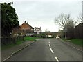
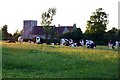
2
Old Bryers Close, Shabbington
New housing development is a major feature of this village.
Image: © Bill Boaden
Taken: 23 Oct 2011
0.05 miles
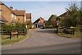
3
Corner house, Shabbington
At the corner of Ickford Road and Crendon Road.
Image: © Robin Webster
Taken: 22 Mar 2020
0.06 miles
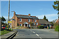
4
St. Mary Magdalene Church, Shabbington
Shabbington is a Buckinghamshire village, about 3 miles (5 km) west of Thame and 7 miles (10 km) WSW of Aylesbury. The village was first recorded in the Domesday Book of 1086, when it was called Sobintone (Anglo-Saxon for Scobba's Estate). Until very recently the village was known as Shobbington; it was only in the Victorian era that the name was changed to its current form. Its church of St Mary Magdalene dates from the eleventh century, its first recorded vicar being Thomas de Bensington (1220).
Image: © Gerald Massey
Taken: 31 Jul 2009
0.10 miles
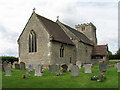
5
St. Mary Magdalene Church, Shabbington
Shabbington is a Buckinghamshire village, about 3 miles (5 km) west of Thame and 7 miles (10 km) WSW of Aylesbury. The village was first recorded in the Domesday Book of 1086, when it was called Sobintone (Anglo-Saxon for Scobba's Estate). Until very recently the village was known as Shobbington; it was only in the Victorian era that the name was changed to its current form. Its church of St Mary Magdalene dates from the eleventh century, its first recorded vicar being Thomas de Bensington (1220). It stands proudly overlooking the fields leading down to the River Thame.
Image: © Gerald Massey
Taken: 31 Jul 2009
0.10 miles
6
St. Mary Magdalene Church, Shabbington
Shabbington is a Buckinghamshire village, about 3 miles (5 km) west of Thame and 7 miles (10 km) WSW of Aylesbury. The village was first recorded in the Domesday Book of 1086, when it was called Sobintone (Anglo-Saxon for Scobba's Estate). Until very recently the village was known as Shobbington; it was only in the Victorian era that the name was changed to its current form. Its church of St Mary Magdalene dates from the eleventh century, its first recorded vicar being Thomas de Bensington (1220). It stands proudly overlooking the fields leading down to the River Thame.
Image: © Gerald Massey
Taken: 31 Jul 2009
0.11 miles
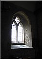
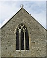
8
St. Mary Magdalene Church, Shabbington
Shabbington is a Buckinghamshire village, about 3 miles (5 km) west of Thame and 7 miles (10 km) WSW of Aylesbury. The village was first recorded in the Domesday Book of 1086, when it was called Sobintone (Anglo-Saxon for Scobba's Estate). Until very recently the village was known as Shobbington; it was only in the Victorian era that the name was changed to its current form. Its church of St Mary Magdalene dates from the eleventh century, the first recorded vicar being Thomas de Bensington (1220). The Church stands proudly overlooking the fields leading down to the River Thame.
Image: © Gerald Massey
Taken: 31 Jul 2009
0.11 miles
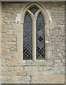
9
St. Mary Magdalene Church, Shabbington
Shabbington is a Buckinghamshire village, about 3 miles (5 km) west of Thame and 7 miles (10 km) WSW of Aylesbury. The village was first recorded in the Domesday Book of 1086, when it was called Sobintone (Anglo-Saxon for Scobba's Estate). Until very recently the village was known as Shobbington; it was only in the Victorian era that the name was changed to its current form. Its church of St Mary Magdalene dates from the eleventh century, its first recorded vicar being Thomas de Bensington (1220).
Image: © Gerald Massey
Taken: 31 Jul 2009
0.11 miles
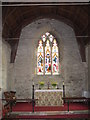
10
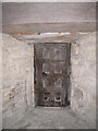
St. Mary Magdalene Church, Shabbington
Shabbington is a Buckinghamshire village, about 3 miles (5 km) west of Thame and 7 miles (10 km) WSW of Aylesbury. The village was first recorded in the Domesday Book of 1086, when it was called Sobintone (Anglo-Saxon for Scobba's Estate). Until very recently the village was known as Shobbington; it was only in the Victorian era that the name was changed to its current form. Its church of St Mary Magdalene dates from the eleventh century, its first recorded vicar being Thomas de Bensington (1220).
I don't know what function this small door set into the Church Wall performs (performed?) - perhaps in times-gone-by it acted as an unglazed window?
Image: © Gerald Massey
Taken: 31 Jul 2009
0.11 miles