IMAGES TAKEN NEAR TO
Menmarsh Road, AYLESBURY, HP18 9GF
Introduction
This page details the photographs taken nearby to Menmarsh Road, HP18 9GF by members of the Geograph project.
The Geograph project started in 2005 with the aim of publishing, organising and preserving representative images for every square kilometre of Great Britain, Ireland and the Isle of Man.

There are currently over 7.5m images from over14,400 individuals and you can help contribute to the project by visiting https://www.geograph.org.uk
Image Map (Loading...)


Getting Data...Please wait
Leaflet Map data © OpenStreetMap
Images are licensed for reuse under creativecommons.org/licenses/by-sa/2.0
Notes
- Clicking on the map will re-center to the selected point.
- The higher the marker number, the further away the image location is from the centre of the postcode.
Image Listing (6 Images Found)
Images are licensed for reuse under creativecommons.org/licenses/by-sa/2.0
Image
Details
Distance
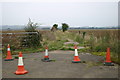
1

Wornal Industrial Park near Worminghall
On site of former RAF base
Image: © al partington
Taken: 31 Jan 2006
0.06 miles
2
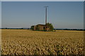
Old airfield building near Worminghall
Corn growing on the disused Oakley Airfield.
Image: © Jackie Harman
Taken: 16 Jul 2006
0.12 miles
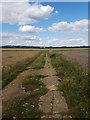
3
Footpath across the old airfield
Footpath across the old Oakley airfield
Image: © Shaun Ferguson
Taken: 7 Oct 2007
0.14 miles
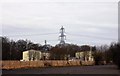
4
Bridleway at the abandoned airfield
RAF Oakley
Image: © R Blackburn
Taken: 11 Jul 2020
0.18 miles
6
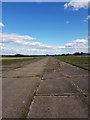
Abandoned Runway
Bridleway along the abandoned runway at RAF Oakley
Image: © R Blackburn
Taken: 11 Jul 2020
0.24 miles