IMAGES TAKEN NEAR TO
Bicester Road, AYLESBURY, HP18 9FN
Introduction
This page details the photographs taken nearby to Bicester Road, HP18 9FN by members of the Geograph project.
The Geograph project started in 2005 with the aim of publishing, organising and preserving representative images for every square kilometre of Great Britain, Ireland and the Isle of Man.

There are currently over 7.5m images from over14,400 individuals and you can help contribute to the project by visiting https://www.geograph.org.uk
Image Map (Loading...)


Getting Data...Please wait
Leaflet Map data © OpenStreetMap
Images are licensed for reuse under creativecommons.org/licenses/by-sa/2.0
Notes
- Clicking on the map will re-center to the selected point.
- The higher the marker number, the further away the image location is from the centre of the postcode.
Image Listing (5 Images Found)
Images are licensed for reuse under creativecommons.org/licenses/by-sa/2.0
Image
Details
Distance
1

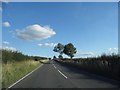
Sunset over Woodway Farm, Long Crendon
Image: © David Howard
Taken: 20 Mar 2016
0.08 miles
2
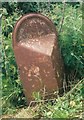
Old Milepost by the B4011, north of Long Crendon
Pressed steel post by the B4011, in parish of Long Crendon (Aylesbury Vale District), Woodway Farm, 10m to right of entrance, on grass verge, where grass cutting stops, on West side of road. Bucks pressing, erected by the County Council in the 20th century.
Inscription once read:-
: (Bicester / 11) : : (Thame / 3) :
Buckinghamshire HER.
HER Number: 1419400000 https://www.heritagegateway.org.uk/Gateway/Results_Single.aspx?uid=MBC32728&resourceID=1024
Milestone Society National ID: BU_THBC03
Image: © N Windle
Taken: 11 Dec 2002
0.10 miles
5
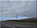
B4011 towards Bicester
North of Long Crendon.
Image: © Robin Webster
Taken: 20 Oct 2018
0.21 miles