IMAGES TAKEN NEAR TO
Old Windmill Way, AYLESBURY, HP18 9BQ
Introduction
This page details the photographs taken nearby to Old Windmill Way, HP18 9BQ by members of the Geograph project.
The Geograph project started in 2005 with the aim of publishing, organising and preserving representative images for every square kilometre of Great Britain, Ireland and the Isle of Man.

There are currently over 7.5m images from over14,400 individuals and you can help contribute to the project by visiting https://www.geograph.org.uk
Image Map (Loading...)


Getting Data...Please wait
Leaflet Map data © OpenStreetMap
Images are licensed for reuse under creativecommons.org/licenses/by-sa/2.0
Notes
- Clicking on the map will re-center to the selected point.
- The higher the marker number, the further away the image location is from the centre of the postcode.
Image Listing (8 Images Found)
Images are licensed for reuse under creativecommons.org/licenses/by-sa/2.0
Image
Details
Distance
1
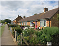
Friars Furlong, Long Crendon
This square is all about the Church and the Court House.
Apart from that, it's either fields or post war suburban housing.
Image: © Des Blenkinsopp
Taken: 14 Jul 2014
0.16 miles
2
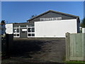
Long Crendon Telephone Exchange
This building, which dates from the early 1970s, is situated in Chearsley Road near Chilton Road. It has the code SMLR and provides telephone and broadband services to 1,519 residential and 160 non-residential premises in Long Crendon plus Chearsley, Chilton and Shabbington nearby. The numbering range of this TE is (01844) 20xxxx, the (01844) referring to the Thame group of nine TEs, and its postcode is HP18 9AW.
Image: © David Hillas
Taken: 21 Oct 2008
0.22 miles
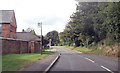
5
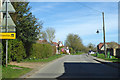
Chearsley Road, Long Crendon
Towards Chearsley.
Image: © Robin Webster
Taken: 22 Mar 2020
0.23 miles
6
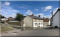
Corner of Burt's Lane
On the edge of the old part of the village.
The house is called The Old Bakery.
The water is from a manhole. A burst water main, I guess.
Image: © Des Blenkinsopp
Taken: 14 Jul 2014
0.23 miles
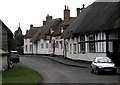
7
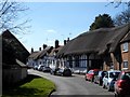
High Street, Long Crendon
A mixture of C16, C17 and C18 buildings
Image: © Bikeboy
Taken: 22 Mar 2015
0.23 miles
8
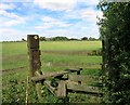
Footpath to College Farm
The large scale map marks this field as a Roman Burial Ground.
Image: © Des Blenkinsopp
Taken: 14 Jul 2014
0.24 miles