IMAGES TAKEN NEAR TO
Chearsley Road, AYLESBURY, HP18 9AP
Introduction
This page details the photographs taken nearby to Chearsley Road, HP18 9AP by members of the Geograph project.
The Geograph project started in 2005 with the aim of publishing, organising and preserving representative images for every square kilometre of Great Britain, Ireland and the Isle of Man.

There are currently over 7.5m images from over14,400 individuals and you can help contribute to the project by visiting https://www.geograph.org.uk
Image Map
Images are licensed for reuse under creativecommons.org/licenses/by-sa/2.0
Notes
- Clicking on the map will re-center to the selected point.
- The higher the marker number, the further away the image location is from the centre of the postcode.
Image Listing (4 Images Found)
Images are licensed for reuse under creativecommons.org/licenses/by-sa/2.0
Image
Details
Distance
1
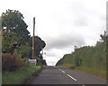
Chearsley road at entrance to Long Crendon
Image: © John Firth
Taken: 25 Sep 2012
0.04 miles
2
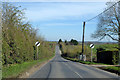
Chearsley Road towards Chearsley
Leaving Long Crendon.
Image: © Robin Webster
Taken: 22 Mar 2020
0.15 miles
3
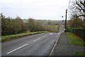
The Chearsley Road
From Long Crendon the Chearsley Road heads away down into the dip
Image: © Shaun Ferguson
Taken: 25 Nov 2007
0.21 miles
4
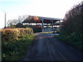
Footpath through College Farm
You need your wits about you following the footpath through College Farm, its quite easy to end up in the sheep handling pen if you mistake a certain gate as footpath access.
Image: © Michael Trolove
Taken: 18 Nov 2012
0.25 miles