IMAGES TAKEN NEAR TO
Pershore Way, AYLESBURY, HP18 0WN
Introduction
This page details the photographs taken nearby to Pershore Way, HP18 0WN by members of the Geograph project.
The Geograph project started in 2005 with the aim of publishing, organising and preserving representative images for every square kilometre of Great Britain, Ireland and the Isle of Man.

There are currently over 7.5m images from over14,400 individuals and you can help contribute to the project by visiting https://www.geograph.org.uk
Image Map (Loading...)


Getting Data...Please wait
Leaflet Map data © OpenStreetMap
Images are licensed for reuse under creativecommons.org/licenses/by-sa/2.0
Notes
- Clicking on the map will re-center to the selected point.
- The higher the marker number, the further away the image location is from the centre of the postcode.
Image Listing (5 Images Found)
Images are licensed for reuse under creativecommons.org/licenses/by-sa/2.0
Image
Details
Distance
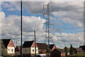
1
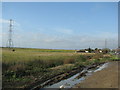
Pylons cross the floodplain of the River Thame
Image: © Sarah Charlesworth
Taken: 12 Nov 2009
0.15 miles
3
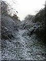
Railway Embankment, Haydon Hill
The embankment of the freight line running north from Aylesbury - over the hedge is the sewage works.
Image: © Katy Walters
Taken: 27 Dec 2005
0.18 miles
4
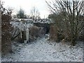
Foot tunnel beneath railway embankment
By the side of the open land to the north of the Haydon Hill estate.
Image: © Katy Walters
Taken: 27 Dec 2005
0.20 miles
5
Aylesbury Sewage Works
At the western outskirts of the town, by the Rabans Lane Industrial Area.
Image: © M J Richardson
Taken: 11 Jul 2013
0.24 miles