IMAGES TAKEN NEAR TO
Lawn Hill, AYLESBURY, HP18 0TT
Introduction
This page details the photographs taken nearby to Lawn Hill, HP18 0TT by members of the Geograph project.
The Geograph project started in 2005 with the aim of publishing, organising and preserving representative images for every square kilometre of Great Britain, Ireland and the Isle of Man.

There are currently over 7.5m images from over14,400 individuals and you can help contribute to the project by visiting https://www.geograph.org.uk
Image Map (Loading...)


Getting Data...Please wait
Leaflet Map data © OpenStreetMap
Images are licensed for reuse under creativecommons.org/licenses/by-sa/2.0
Notes
- Clicking on the map will re-center to the selected point.
- The higher the marker number, the further away the image location is from the centre of the postcode.
Image Listing (22 Images Found)
Images are licensed for reuse under creativecommons.org/licenses/by-sa/2.0
Image
Details
Distance
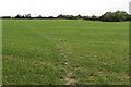
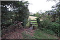
2
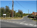
Buckingham Road
Buckingham Road passing the right turn up Lawn Hill towards Shipton Lee
Image: © Shaun Ferguson
Taken: 19 Feb 2010
0.07 miles
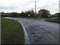
3
House on junction of Buckingham Road / Lawn Hill, Edgcott
Image: © JThomas
Taken: 21 Sep 2019
0.08 miles
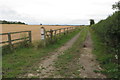
4
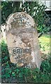
Old Milepost by Buckingham Road, Edgcott
Pressed steel post by the UC road, in parish of Edgcott (Aylesbury Vale District), Buckingham Road; North East edge of Edgcott village, before junction with Perry Hill and Lawn Hill, on well kept grass verge, leaning into a bush, on East side of road. Bucks pressing, erected by the County Council in the 20th century.
Inscription reads:-
: BRILL / 8 : : EDGCOTT / PARISH : : BUCKINGHAM / 8 :
Buckinghamshire HER.
HER Number: 1356000000 https://www.heritagegateway.org.uk/Gateway/Results_Single.aspx?uid=MBC25689&resourceID=1024
Milestone Society National ID: BU_BRBU08
Image: © A Rosevear & J Higgins
Taken: 25 Jul 2002
0.11 miles
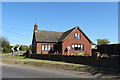
5
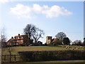
Edgcott
The view from the bottom of Perry Hill.
Image: © Andrew Smith
Taken: 4 Mar 2006
0.12 miles
10
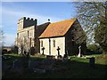
St. Michael's & All Angels in its churchyard
This view is taken from just a few paces north of Image The eastern end is still in heavy shadow contrasting with the adjacent brightly lit southern wall of the chancel. The flat farmland of the Vale of Aylesbury can be seen extending out to the distance. St.Michael is a common appellation for churches situated atop hills, as St.Michael (an archangel not a human saint) is said to have done battle with the Devil, and the latter was supposed to pop out of the tops of hills. Having said that, while this church is on slightly elevated ground I wouldn't go so far as to call it a hill !
Image: © Rob Farrow
Taken: 12 Jan 2008
0.18 miles