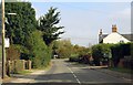
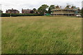
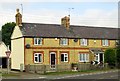
IMAGES TAKEN NEAR TO
Buckingham Road, AYLESBURY, HP18 0TP
Introduction
This page details the photographs taken nearby to Buckingham Road, HP18 0TP by members of the Geograph project.
The Geograph project started in 2005 with the aim of publishing, organising and preserving representative images for every square kilometre of Great Britain, Ireland and the Isle of Man.

There are currently over 7.5m images from over14,400 individuals and you can help contribute to the project by visiting https://www.geograph.org.uk
Image Map
Images are licensed for reuse under creativecommons.org/licenses/by-sa/2.0
Notes
- Clicking on the map will re-center to the selected point.
- The higher the marker number, the further away the image location is from the centre of the postcode.
Image Listing (26 Images Found)
Images are licensed for reuse under creativecommons.org/licenses/by-sa/2.0
Image
Details
Distance

10
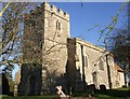
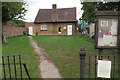
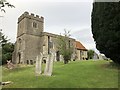
St. Michael & All Angels - Tower end
As Image] is bisected by the 6800 gridline, the tower of the church is in a different square to the chancel. This photo was taken from near the gate into the churchyard from Church Lane.
Image: © Rob Farrow
Taken: 12 Jan 2008
0.16 miles