IMAGES TAKEN NEAR TO
Edgcott, AYLESBURY, HP18 0QW
Introduction
This page details the photographs taken nearby to HP18 0QW by members of the Geograph project.
The Geograph project started in 2005 with the aim of publishing, organising and preserving representative images for every square kilometre of Great Britain, Ireland and the Isle of Man.

There are currently over 7.5m images from over14,400 individuals and you can help contribute to the project by visiting https://www.geograph.org.uk
Image Map
Images are licensed for reuse under creativecommons.org/licenses/by-sa/2.0
Notes
- Clicking on the map will re-center to the selected point.
- The higher the marker number, the further away the image location is from the centre of the postcode.
Image Listing (12 Images Found)
Images are licensed for reuse under creativecommons.org/licenses/by-sa/2.0
Image
Details
Distance
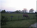
1
Edgcott House near Edgcott
Edgcott House lies just off the C road that runs between Greatmoor and Edgcott. On the OS 1:50,000 map, this is shown as Rosall Farm, but this refers to the farm off camera to the right which is now named Prune Farm.
Image: © Andy Gryce
Taken: 29 Apr 2007
0.03 miles
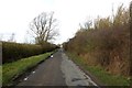
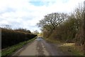
2
Lane towards Edgcott
One of several minor roads in this area, and some not so minor, suffering from foundation failure and rutting of the tarmac. The section ahead has been much patched.
Image: © Robin Webster
Taken: 20 Oct 2018
0.04 miles
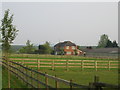
3
Prune Farm near Edgcott
As well the sign on the wooden fence, a sign just showing to the right of the photo says 'Prune Farm & Barn Owls - Entry is restricted by security gates' with letter boxes for each. The farm is known for rearing show ponies.
Image: © Andy Gryce
Taken: 21 Apr 2007
0.05 miles
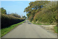
5
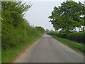
Lawn Hill road near Edgcott
This first part of the C road that runs from Edgcott, behind the camera, to Greatmoor, and then onto Shipton Lee near Quainton, is named Lawn Hill. There is a Lawn Hill Farm nearer to Edgcott.
Image: © Andy Gryce
Taken: 29 Apr 2007
0.07 miles
7
Driveway, Prune Farm near Edgcott
This track or driveway comes from the C road between Greatmoor and Edgcott which is behind the camera. On the OS 1:50,000 map Prune Farm is marked as Rosall Farm, though on the historic OS 1940s map it is marked as Prune Farm. The buildings of HM Prison Grendon are in the far distance on the right. The driveway is also a footpath that after Prune Farm continues to the C road south of the village of Edgcott about 1km away.
Image: © Andy Gryce
Taken: 29 Apr 2007
0.13 miles
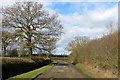
8
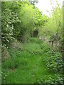
Footpath near Edgcott
This underused footpath runs from the C road between Greatmoor and Edgcott which is behind the camera, and Calvert landfill site.
Image: © Andy Gryce
Taken: 29 Apr 2007
0.15 miles
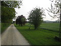
9
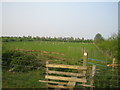
Footpath near Prune Farm Cottages, Edgcott
This view looking north-east is of a footpath from Grendon Underwood just before it reaches Lawn Hill road south of Edgcott, which is behind the line of bushes in the distance. The hedge fence just beyond the stile is being re-laid.
Image: © Andy Gryce
Taken: 29 Apr 2007
0.18 miles