IMAGES TAKEN NEAR TO
Woodham, AYLESBURY, HP18 0QH
Introduction
This page details the photographs taken nearby to HP18 0QH by members of the Geograph project.
The Geograph project started in 2005 with the aim of publishing, organising and preserving representative images for every square kilometre of Great Britain, Ireland and the Isle of Man.

There are currently over 7.5m images from over14,400 individuals and you can help contribute to the project by visiting https://www.geograph.org.uk
Image Map
Images are licensed for reuse under creativecommons.org/licenses/by-sa/2.0
Notes
- Clicking on the map will re-center to the selected point.
- The higher the marker number, the further away the image location is from the centre of the postcode.
Image Listing (3 Images Found)
Images are licensed for reuse under creativecommons.org/licenses/by-sa/2.0
Image
Details
Distance
2

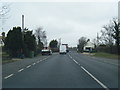
The A41 to Aylesbury
The A41 follows the Roman road, Akeman Street.
Image: © Steve Daniels
Taken: 4 May 2014
0.16 miles
3
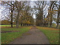
Tree Lined Avenue
The footpath up to the A41 heads up a tree lined avenue, presumably in the past another entrance to Wotton House estate
Image: © Shaun Ferguson
Taken: 31 Oct 2009
0.19 miles