IMAGES TAKEN NEAR TO
Woodham, AYLESBURY, HP18 0PR
Introduction
This page details the photographs taken nearby to HP18 0PR by members of the Geograph project.
The Geograph project started in 2005 with the aim of publishing, organising and preserving representative images for every square kilometre of Great Britain, Ireland and the Isle of Man.

There are currently over 7.5m images from over14,400 individuals and you can help contribute to the project by visiting https://www.geograph.org.uk
Image Map
Images are licensed for reuse under creativecommons.org/licenses/by-sa/2.0
Notes
- Clicking on the map will re-center to the selected point.
- The higher the marker number, the further away the image location is from the centre of the postcode.
Image Listing (7 Images Found)
Images are licensed for reuse under creativecommons.org/licenses/by-sa/2.0
Image
Details
Distance
1
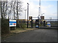
National Grid station 2
This is the high security entrance to the Aylesbury Gas Compressor Station operated by National Grid, see Image The entrance is at the end of a 1km long gated private road, which is also a public bridleway, off from the A41.
Image: © Andy Gryce
Taken: 25 Mar 2007
0.03 miles
2

National Grid station
This is the Aylesbury Compressor Station operated by National Grid which is at the end of a 1km long gated private road, which is also a public bridleway, off from the A41. Aylesbury is one of 24 gas compressor stations around the country that maintains gas pressure during periods of high demand. Security fences and cameras were much in evidence though the site was very quiet, probably because it was a Sunday.
Image: © Andy Gryce
Taken: 25 Mar 2007
0.03 miles
3
Private road to National Grid station
Looking north-east, this private road that comes from the A41 behind the camera serves the Aylesbury Compressor Station of the National Grid, which can be seen in the distance. The road is also a bridleway which goes to Shipton Lee 3km away.
Image: © Andy Gryce
Taken: 25 Mar 2007
0.06 miles
4
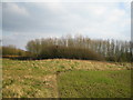
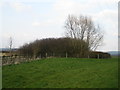
Mill Mound
This mound is Mill Mound and may be the site of a tumulus, moated mount (the mound is surrounded by water) or in more recent times, the site of a vanished post-mill. Behind the mound and the hedge is the bridleway between Woodham to the south and Shipton Lee to the north.
Image: © Andy Gryce
Taken: 25 Mar 2007
0.07 miles
5
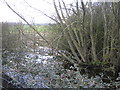
Moat, Mill Mound
This could be the remains of a moat that surrounds the east side of Mill Mound,Image, as there are quite a few moated sites in the area. Given the small size of the mound however it is more likely to simply be water filling a hollow to one side of the mound.
Image: © Andy Gryce
Taken: 25 Mar 2007
0.09 miles
6
Mill Mound 2
This is the east side of Mill Mound, see Image, as seen from the bridleway between Woodham to the south and Shipton Lee to the north. Just off camera to the right a footpath between Waddesdon to the east and Grendon Underwood in the west, crosses the bridleway.
Image: © Andy Gryce
Taken: 25 Mar 2007
0.10 miles
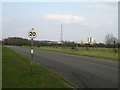
7
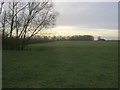
Bridleway heading to Mill Mound
Bridleway heading to Mill Mound by the aerial
Image: © Shaun Ferguson
Taken: 23 Jan 2016
0.20 miles