IMAGES TAKEN NEAR TO
Church Lane, AYLESBURY, HP18 0PJ
Introduction
This page details the photographs taken nearby to Church Lane, HP18 0PJ by members of the Geograph project.
The Geograph project started in 2005 with the aim of publishing, organising and preserving representative images for every square kilometre of Great Britain, Ireland and the Isle of Man.

There are currently over 7.5m images from over14,400 individuals and you can help contribute to the project by visiting https://www.geograph.org.uk
Image Map (Loading...)


Getting Data...Please wait
Leaflet Map data © OpenStreetMap
Images are licensed for reuse under creativecommons.org/licenses/by-sa/2.0
Notes
- Clicking on the map will re-center to the selected point.
- The higher the marker number, the further away the image location is from the centre of the postcode.
Image Listing (9 Images Found)
Images are licensed for reuse under creativecommons.org/licenses/by-sa/2.0
Image
Details
Distance
3

Westcott School
Probably one of the smallest schools in England
Image: © Ed Andrews
Taken: 19 Jun 2008
0.10 miles
4
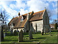
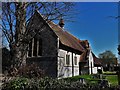
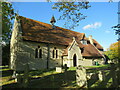
St Mary, Westcott
Designed by G E Street, 1866-67, St Mary's is one of the most lauded of his small new mission churches for the diocese of Oxford; mostly owing to the powerful austerity of the interior.
Image: © Chris Brown
Taken: 19 Apr 2018
0.10 miles
5
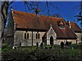
St Mary, Westcott
G E Street designed the church as Oxford diocesan surveyor in 1866-67 and probably also the village school beyond where the church key is kept.
Image: © Chris Brown
Taken: 19 Apr 2018
0.10 miles
7
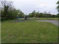
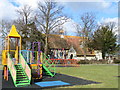
Wescott Playground
Wescott Playground by St Mary's Church
Image: © Shaun Ferguson
Taken: 4 May 2009
0.12 miles
8
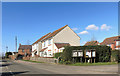
Parish Notices, Westcott High Street
Image: © Des Blenkinsopp
Taken: 10 Mar 2015
0.19 miles
9
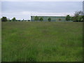
Old Hangar
Old Hangar on South East edge of Wescott Airfield
Image: © Shaun Ferguson
Taken: 4 May 2009
0.23 miles