IMAGES TAKEN NEAR TO
High Street, AYLESBURY, HP18 0LB
Introduction
This page details the photographs taken nearby to High Street, HP18 0LB by members of the Geograph project.
The Geograph project started in 2005 with the aim of publishing, organising and preserving representative images for every square kilometre of Great Britain, Ireland and the Isle of Man.

There are currently over 7.5m images from over14,400 individuals and you can help contribute to the project by visiting https://www.geograph.org.uk
Image Map (Loading...)


Getting Data...Please wait
Leaflet Map data © OpenStreetMap
Images are licensed for reuse under creativecommons.org/licenses/by-sa/2.0
Notes
- Clicking on the map will re-center to the selected point.
- The higher the marker number, the further away the image location is from the centre of the postcode.
Image Listing (88 Images Found)
Images are licensed for reuse under creativecommons.org/licenses/by-sa/2.0
Image
Details
Distance
1
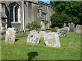
Old graves at St Michael & All Angels, Waddesdon
Elaborately carved gravestones in the churchyard
Image: © Eirian Evans
Taken: 15 Jun 2013
0.01 miles
2
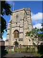
St Michael & All Angels, Waddesdon
The church dates from the 12th C. The construction began in 1190, it was extended and embellished many times over the centuries, especially during the medieval and Victorian perods.This church tower was rebuilt in 1892, replacing the one built during the 14th century.
Image: © Eirian Evans
Taken: 15 Jun 2013
0.01 miles
3
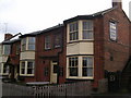
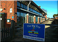
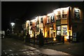
Waddesdon: The Lion PH
Brick built roadside pub
Image: © Chris Cursley
Taken: 7 May 2010
0.02 miles
4
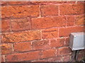
OS Cut Mark, The Lion PH, Waddesdon
Eroding OS cut mark on brickwork. Further information on all OS marks can be found at http://www.bench-marks.org.uk
Image: © Chris Cursley
Taken: 7 May 2010
0.02 miles
5
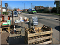
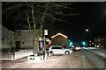
Things for sale, Waddesdon High Street
Image: © Des Blenkinsopp
Taken: 6 Apr 2015
0.02 miles
6
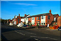
The Lion, Waddesdon
The public house has evidently acquired a row of houses and is now a hotel.
Image: © Humphrey Bolton
Taken: 30 Jan 2022
0.02 miles
7
Unusual windows on a nursery building
The top part of the row of windows slopes sharply outward to meet the edge of the roof.
Image: © Humphrey Bolton
Taken: 30 Jan 2022
0.02 miles
10
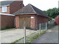
Former Telephone Exchange, Waddesdon
Located between 3 and 5 Frederick Street, near the A41 High Street, this former TE, now a garage, was replaced by a larger TE near Quainton Road Station in the early 1980s, SP7319 refershttp://www.geograph.org.uk/photo/2049019. The postcode of this ex-TE is HP18 0LU.
Image: © David Hillas
Taken: 1 Sep 2010
0.03 miles