IMAGES TAKEN NEAR TO
Alma Street, AYLESBURY, HP18 0FU
Introduction
This page details the photographs taken nearby to Alma Street, HP18 0FU by members of the Geograph project.
The Geograph project started in 2005 with the aim of publishing, organising and preserving representative images for every square kilometre of Great Britain, Ireland and the Isle of Man.

There are currently over 7.5m images from over14,400 individuals and you can help contribute to the project by visiting https://www.geograph.org.uk
Image Map (17 Images)


Getting Data...Please wait
Leaflet Map data © OpenStreetMap
Images are licensed for reuse under creativecommons.org/licenses/by-sa/2.0
Notes
- Clicking on the map will re-center to the selected point.
- The higher the marker number, the further away the image location is from the centre of the postcode.
Image Listing (17 Images Found)
Images are licensed for reuse under creativecommons.org/licenses/by-sa/2.0
Image
Details
Distance
1
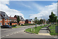
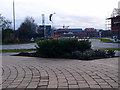
Redcurrant Avenue and Paradise Orchard
A fruity sound to this road junction in the middle of Berryfields. Paradise Orchard is one of the main roads through the maze of residential streets which are all around.
Image: © Des Blenkinsopp
Taken: 5 Jul 2021
0.09 miles
2
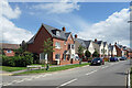
Paradise Orchard, Berryfields
An exotic sounding street name in the middle of Berryfields.
Image: © Des Blenkinsopp
Taken: 5 Jul 2021
0.10 miles
3
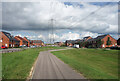
Space for the Cables
A recently built area of housing on the edge of Aylesbury. The pylons were here long before the builders and a wide space has had to be left in between the new housing developments. A cycleway with lawns fills the space.
Image: © Des Blenkinsopp
Taken: 5 Jul 2021
0.15 miles
4
Berryfield, Aylesbury
Housing development on the edge of Aylesbury.
Image: © Michael Trolove
Taken: 30 Dec 2012
0.19 miles
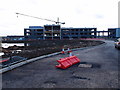
5
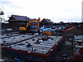
Construction Site
Berryfield, a housing development on the edge of Aylesbury.
Image: © Michael Trolove
Taken: 30 Dec 2012
0.19 miles
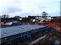
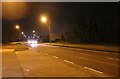
6
Construction Site
Large office or similar being built on the edge of Aylesbury.
Photo location may need adjusting when OS mapping is updated.
Image: © Michael Trolove
Taken: 30 Dec 2012
0.20 miles
7
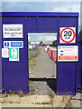
Door to the Building Site
Another construction site picture in this rapidly developing area. This is along Redcurrant Avenue.
Image: © Des Blenkinsopp
Taken: 5 Jul 2021
0.21 miles
8
Berryfield, Aylesbury
A new housing development on the edge of Aylesbury.
Image: © Michael Trolove
Taken: 30 Dec 2012
0.23 miles
10
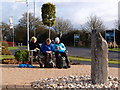
Lunch break in Berryfield
LDWA members enjoying a sit down after an arduous mornings walk on extremely wet going underfoot.
Image: © Michael Trolove
Taken: 30 Dec 2012
0.23 miles