IMAGES TAKEN NEAR TO
Upper Winchendon, AYLESBURY, HP18 0ET
Introduction
This page details the photographs taken nearby to HP18 0ET by members of the Geograph project.
The Geograph project started in 2005 with the aim of publishing, organising and preserving representative images for every square kilometre of Great Britain, Ireland and the Isle of Man.

There are currently over 7.5m images from over14,400 individuals and you can help contribute to the project by visiting https://www.geograph.org.uk
Image Map (Loading...)


Getting Data...Please wait
Leaflet Map data © OpenStreetMap
Images are licensed for reuse under creativecommons.org/licenses/by-sa/2.0
Notes
- Clicking on the map will re-center to the selected point.
- The higher the marker number, the further away the image location is from the centre of the postcode.
Image Listing (6 Images Found)
Images are licensed for reuse under creativecommons.org/licenses/by-sa/2.0
Image
Details
Distance
3
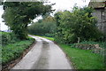
Lane past North Lodge
Lane past North Lodge heading to Coney Hill Farm
Image: © Shaun Ferguson
Taken: 25 Oct 2007
0.12 miles
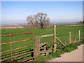
4
Field of broad beans
By public bridleway near North Lodge of Eythrop Park.
Image: © David Hawgood
Taken: 15 Jun 2007
0.16 miles
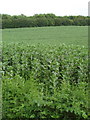
5
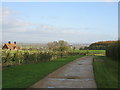
Concrete road near Coney Hill Farm with Aylesbury in the background
Image: © Pip Rolls
Taken: 15 Nov 2005
0.17 miles
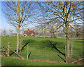
6
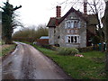
North Lodge
A dwelling on Coney Hill.
Image: © Michael Trolove
Taken: 30 Dec 2012
0.22 miles