IMAGES TAKEN NEAR TO
Upper Winchendon, AYLESBURY, HP18 0ER
Introduction
This page details the photographs taken nearby to HP18 0ER by members of the Geograph project.
The Geograph project started in 2005 with the aim of publishing, organising and preserving representative images for every square kilometre of Great Britain, Ireland and the Isle of Man.

There are currently over 7.5m images from over14,400 individuals and you can help contribute to the project by visiting https://www.geograph.org.uk
Image Map (Loading...)


Getting Data...Please wait
Leaflet Map data © OpenStreetMap
Images are licensed for reuse under creativecommons.org/licenses/by-sa/2.0
Notes
- Clicking on the map will re-center to the selected point.
- The higher the marker number, the further away the image location is from the centre of the postcode.
Image Listing (6 Images Found)
Images are licensed for reuse under creativecommons.org/licenses/by-sa/2.0
Image
Details
Distance
1
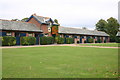
Waddesdon stud
Waddesdon stud by the Bernwood Way
Image: © Shaun Ferguson
Taken: 21 Sep 2007
0.03 miles
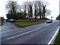
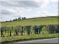
4
Waddesdon Hill north of Waddesdon Stud turning
Image: © John Firth
Taken: 25 Sep 2012
0.13 miles
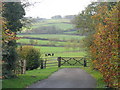
5
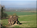
View from a stump
Looking north over Aylesbury Vale from Waddesdon Hill.
Image: © Des Blenkinsopp
Taken: 6 Apr 2015
0.24 miles
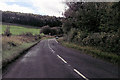
6
Old land slips, Waddesdon Hill
The geology seems to be Kimmeridge Clay.
Image: © Robin Webster
Taken: 27 Mar 2015
0.24 miles