IMAGES TAKEN NEAR TO
Upper Winchendon, AYLESBURY, HP18 0EP
Introduction
This page details the photographs taken nearby to HP18 0EP by members of the Geograph project.
The Geograph project started in 2005 with the aim of publishing, organising and preserving representative images for every square kilometre of Great Britain, Ireland and the Isle of Man.

There are currently over 7.5m images from over14,400 individuals and you can help contribute to the project by visiting https://www.geograph.org.uk
Image Map
Images are licensed for reuse under creativecommons.org/licenses/by-sa/2.0
Notes
- Clicking on the map will re-center to the selected point.
- The higher the marker number, the further away the image location is from the centre of the postcode.
Image Listing (10 Images Found)
Images are licensed for reuse under creativecommons.org/licenses/by-sa/2.0
Image
Details
Distance
1
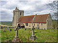
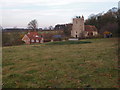
Upper Winchendon church
St. Mary Magdalen's.
Image: © Robin Webster
Taken: 27 Mar 2015
0.10 miles
2
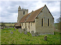
Upper Winchendon church
St. Mary Magdalen's is a grade I listed building, 12th century with 14th century additions and a 15th century tower.
Image: © Robin Webster
Taken: 27 Mar 2015
0.10 miles
3
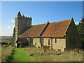
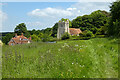
St Mary Magdalene, Upper Winchendon
Upper Winchendon is small village, about 1.5 miles south of Waddesdon and 4.5 miles west of Aylesbury. You can drive through the village and not know the church is there:set on a hill with spectacular views, it has no electricity, heating or lighting but is a very good example of a country church in its ancient form.
Construction of the nave of St Mary Magdalene started around 1100. A little later (around 1150), the more ornate round-headed Norman south doorway was probably added, with jamb shafts enriched with twisted and lozenge ornament surmounted by scalloped capitals.
Image: © Richard Rogerson
Taken: 8 Oct 2022
0.10 miles
4
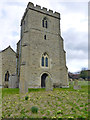
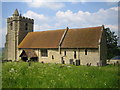
Tower, Upper Winchendon church
St. Mary Magdalen's is a grade I listed building, 12th century with 14th century additions and a 15th century tower.
Image: © Robin Webster
Taken: 27 Mar 2015
0.11 miles
5
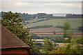
Upper Winchendon church viewed from Ashendon
Image: © Roger Davies
Taken: 21 Aug 2010
0.11 miles
7
Pasture, Upper Winchendon
A footpath approaches St Mary's church from the west.
Image: © Andrew Smith
Taken: 3 Jun 2023
0.12 miles
8
Upper Winchendon: The Church of St Mary Magdalene
Tucked away unsurprisingly down Church Lane.
Image: © Nigel Cox
Taken: 7 Jun 2006
0.13 miles
9
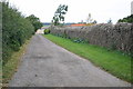
Lane to Church
Lane to Church at Upper Winchendon
Image: © Shaun Ferguson
Taken: 21 Sep 2007
0.13 miles
10

Downhill Path at Upper Winchendon
Hilltop Upper Winchendon is around 60 metres higher than its partner Nether Winchendon down by the river.
Image: © Des Blenkinsopp
Taken: 6 Apr 2015
0.25 miles