IMAGES TAKEN NEAR TO
Stockwell Lane, AYLESBURY, HP17 9UH
Introduction
This page details the photographs taken nearby to Stockwell Lane, HP17 9UH by members of the Geograph project.
The Geograph project started in 2005 with the aim of publishing, organising and preserving representative images for every square kilometre of Great Britain, Ireland and the Isle of Man.

There are currently over 7.5m images from over14,400 individuals and you can help contribute to the project by visiting https://www.geograph.org.uk
Image Map
Images are licensed for reuse under creativecommons.org/licenses/by-sa/2.0
Notes
- Clicking on the map will re-center to the selected point.
- The higher the marker number, the further away the image location is from the centre of the postcode.
Image Listing (5 Images Found)
Images are licensed for reuse under creativecommons.org/licenses/by-sa/2.0
Image
Details
Distance
1

Waldridge Manor
Taken from the footpath which crosses to the south of the house
Image: © David Hawgood
Taken: 30 Aug 2005
0.06 miles
2
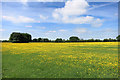
Waldridge's Fields
Farmers from the vanished village of Waldridge would have worked here centuries ago.
Look carefully, and the outlines of the old ridge and furrow fields are still marked out by the buttercups which grow more strongly on the ridges.
Image: © Des Blenkinsopp
Taken: 27 May 2015
0.12 miles
3
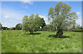
Site of Waldridge Village
A vanished medieval settlement site.
The manor house is all that's left.
Image: © Des Blenkinsopp
Taken: 27 May 2015
0.15 miles
4
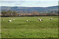
Pasture, Ford
Sheep grazing on the humps and bumps that are the remains of Waldridge medieval village. Most of the village seems to have been in the upper part of this field. The evidence is clearly visible in aerial imagery and includes the line of a former trackway. The Chiltern scarp is in the background with Beacon Hill towards the left.
Image: © Andrew Smith
Taken: 2 Jan 2021
0.17 miles
5
Footpath to Waldridge Manor
Footpath by the hedge up to Waldridge Manor
Image: © Shaun Ferguson
Taken: 9 Feb 2009
0.21 miles