IMAGES TAKEN NEAR TO
Pippin Place, HP17 9AP
Introduction
This page details the photographs taken nearby to Pippin Place, HP17 9AP by members of the Geograph project.
The Geograph project started in 2005 with the aim of publishing, organising and preserving representative images for every square kilometre of Great Britain, Ireland and the Isle of Man.

There are currently over 7.5m images from over14,400 individuals and you can help contribute to the project by visiting https://www.geograph.org.uk
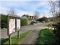
Image Map
Images are licensed for reuse under creativecommons.org/licenses/by-sa/2.0
Notes
- Clicking on the map will re-center to the selected point.
- The higher the marker number, the further away the image location is from the centre of the postcode.
Image Listing (11 Images Found)
Images are licensed for reuse under creativecommons.org/licenses/by-sa/2.0
Image
Details
Distance
3
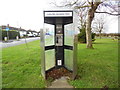
Former KX300 Telephone Kiosk at Smokey Row
Situated in Grove Lane HP17 9TR, this telephone kiosk has a BT notice on its left indicating that it will shortly be taken out of service due to lack of usage. The former BT Piper logo can be seen on each side whilst there is a No Smoking Notice below the payphone. Update: the telephone kiosk has since been removed from this location.
Image: © David Hillas
Taken: 4 Jan 2017
0.08 miles
4
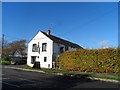
The Swan, Smokey Row
I thought this pub was called "The Swan and Butcher" - but now it's just called The Swan. It was closed for a while - so perhaps that's when the butcher left ... unless I'm imagining him !
Image: © Rob Farrow
Taken: 29 Apr 2006
0.11 miles
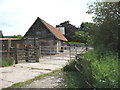
5
Smokey Row: The Swan public house
The 1885 Ordnance Survey map shows the pub as the only building in the vicinity while Smokey Row is spelt Smoky Row and refers to a hamlet on the track leading to Great Kimble, but on the west side of the railway. Even by 1922 the Ordnance Survey map shows few changes and Smokey Row is still Smoky Row.
Image: © Nigel Cox
Taken: 30 Mar 2008
0.11 miles
6
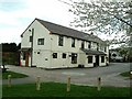
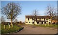
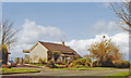
Grove Farm
Farm buildings and yard at Grove Farm viewed from the fields. The B4009 is at the opposite (southeastern) end of the yard.
Image: © Martin Addison
Taken: 4 Jun 2006
0.18 miles
7
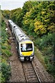
Train near Askett
Chiltern Railways unit No.168110 near Askett with an Aylesbury to London Marylebone (via Princes Risborough) train.
Image: © Bob Walters
Taken: 8 Oct 2018
0.22 miles
8
Little Kemble: a delightful rural station (I)
Image: © Basher Eyre
Taken: 23 May 2021
0.24 miles
9
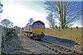
A landfill waste train approaching Little Kimble Station
Class 66 No. 66148 approaches Little Kimble with a train of landfill wagons headed for the disposal site at Calvert, north of Aylesbury. These trains run every day, bringing spoil from the London area to fill the old claypits.
Image: © Bob Walters
Taken: 25 Feb 2019
0.24 miles
10
Little Kimble station, 1990
View NW from the A4010 road: ex-GWR Princes Risborough - Aylesbury line. The station and line are still functioning, but the house is now privately occupied. (Cf. Image]).
Image: © Ben Brooksbank
Taken: 16 Apr 1990
0.24 miles