IMAGES TAKEN NEAR TO
Baghill Lane, AYLESBURY, HP17 8ZE
Introduction
This page details the photographs taken nearby to Baghill Lane, HP17 8ZE by members of the Geograph project.
The Geograph project started in 2005 with the aim of publishing, organising and preserving representative images for every square kilometre of Great Britain, Ireland and the Isle of Man.

There are currently over 7.5m images from over14,400 individuals and you can help contribute to the project by visiting https://www.geograph.org.uk
Image Map
Images are licensed for reuse under creativecommons.org/licenses/by-sa/2.0
Notes
- Clicking on the map will re-center to the selected point.
- The higher the marker number, the further away the image location is from the centre of the postcode.
Image Listing (7 Images Found)
Images are licensed for reuse under creativecommons.org/licenses/by-sa/2.0
Image
Details
Distance
2
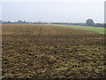
Field by railway line
Field by railway line just north west of Haddenham and Thame parkway station
Image: © Shaun Ferguson
Taken: 18 Sep 2008
0.19 miles
3

Signpost at the Crossing
A very substantial signpost where a footpath crosses a bridleway.
Image: © Des Blenkinsopp
Taken: 13 Feb 2019
0.24 miles
5
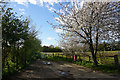
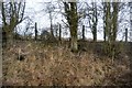
Path to Snakemoor
Snakemoor is a small nature reserve near Haddenham.
Image: © Bill Boaden
Taken: 29 Apr 2016
0.24 miles
6
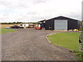
Cotteshill Farm, Haddenham
Taken from Station Road - which leads to the former station, not the present one.
Image: © David Hawgood
Taken: 25 Aug 2005
0.24 miles