IMAGES TAKEN NEAR TO
Ford, AYLESBURY, HP17 8XH
Introduction
This page details the photographs taken nearby to HP17 8XH by members of the Geograph project.
The Geograph project started in 2005 with the aim of publishing, organising and preserving representative images for every square kilometre of Great Britain, Ireland and the Isle of Man.

There are currently over 7.5m images from over14,400 individuals and you can help contribute to the project by visiting https://www.geograph.org.uk
Image Map
Images are licensed for reuse under creativecommons.org/licenses/by-sa/2.0
Notes
- Clicking on the map will re-center to the selected point.
- The higher the marker number, the further away the image location is from the centre of the postcode.
Image Listing (27 Images Found)
Images are licensed for reuse under creativecommons.org/licenses/by-sa/2.0
Image
Details
Distance
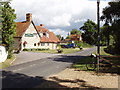
1
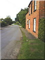
The Old Bakehouse and road to Dinton
Image: © Roger Templeman
Taken: 9 Sep 2010
0.04 miles
2
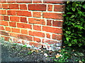
Benchmark on The Old Bakehouse
Ordnance Survey cut mark benchmark described on the Bench Mark Database at http://www.bench-marks.org.uk/bm35482.
Image: © Roger Templeman
Taken: 9 Sep 2010
0.04 miles
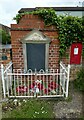
4
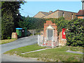
Memorial and Mail Box at Ford
Ford's war memorial is a simple engraved tablet mounted on a wall.
The wall is a lot older than the housing behind it and has no doubt been preserved because of the memorial.
Image: © Des Blenkinsopp
Taken: 13 Sep 2020
0.04 miles
7
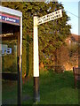
Direction Sign ? Signpost
Located on the east side of the staggered crossroads in Ford village in Dinton with Ford and Upton parish. 1 arm and ball finial. It dates from the 1920s or 1930s. By 2019 the telephone box had been removed.
Milestone Society National ID: BU_SP7709
Image: © John V Nicholls
Taken: 22 Mar 2010
0.05 miles
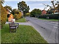
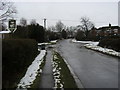
8
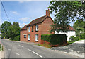
Ford village
This is the road to Moat farm
Image: © David Hawgood
Taken: 25 Aug 2005
0.05 miles
9
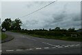
Village Crossroad
Village Crossroad with Water Lane by The Dinton Hermit pub sign and Chapel Road to the right
Image: © Shaun Ferguson
Taken: 9 Feb 2009
0.06 miles