IMAGES TAKEN NEAR TO
School Lane, AYLESBURY, HP17 8UZ

Introduction

This page details the photographs taken nearby to School Lane, HP17 8UZ by members of the Geograph project.

The Geograph project started in 2005 with the aim of publishing, organising and preserving representative images for every square kilometre of Great Britain, Ireland and the Isle of Man.

There are currently over 7.5m images from over14,400 individuals and you can help contribute to the project by visiting https://www.geograph.org.uk

Image Map


Images are licensed for reuse under creativecommons.org/licenses/by-sa/2.0
Notes
  • Clicking on the map will re-center to the selected point.
  • The higher the marker number, the further away the image location is from the centre of the postcode.

Image Listing (62 Images Found)

Images are licensed for reuse under creativecommons.org/licenses/by-sa/2.0
  • ...
Image
Details
Distance
1
Wallace Farm
Wallace Farm, Dinton
Image: © Cered Taken: 28 Oct 1998
0.08 miles
2
Benchmark on Dinton Croft
Ordnance Survey cut mark benchmark described on the Bench Mark Database at http://www.bench-marks.org.uk/bm35477.
Image: © Roger Templeman Taken: 9 Sep 2010
0.14 miles
3
Forge Cottage, Dinton, Buckinghamshire
C17 and C18. Rubblestone with old tile roof some timber framing. Weatherboarded range on rubble plinth at right, formerly the smithy. Old tile roof at lower level than house. One and a half storeys. 3 bays. 4 Panel door between right hand bays in front of stack forming lobby-entry type plan. Board door at far right. Leaded casement windows. 2-light to left bays under timber lintels, 3-light to right bay with cement rusticated quoins and arch. 3 two light gabled dormers. Left gable timber framed with brick infill, right gable weatherboarded. Stack between right hand bays. Outshots to rear and some exposed timber- framing. Single-storey range at right has stack. Rear wall weatherboarded. (Source:Historic England)
Image: © Oswald Bertram Taken: 9 Jul 2015
0.15 miles
4
School Lane, Dinton
The parish church and these few neighbouring houses are separated from the rest of Dinton village by the grounds of Dinton Hall.
Image: © Des Blenkinsopp Taken: 15 Feb 2019
0.15 miles
5
Dinton Churchyard Gate
The southern entrance to the churchyard, looking out to some of the houses near the church. Most of Dinton village is a short distance to the west on the other side of Dinton Hall and its gardens.
Image: © Des Blenkinsopp Taken: 15 Feb 2019
0.17 miles
6
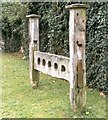
Dinton stocks
The answer to minor crime in the 17th century, these stocks still stand on Dinton village green near the church. At the left end is the whipping post with iron manacles attached. See Article at: http://books.google.co.uk/books?id=2_ZstVBZSfIC&lpg=PP1&pg=PA33#v=onepage&q=&f=true , and Gallery at: http://www.geograph.org.uk/gallery/the_roundhead_conspirators_of_aylesbury_8777
Image: © D Gore Taken: Unknown
0.18 miles
7
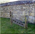
Stocks by boundary wall south of SS Peter & Paul, Dinton
These stocks are to be found adjacent to the stone boundary wall to the south of Dinton's SS Peter & Paul church. There is another set of stocks inside the church porch (see Image]) ... Dinton obviously had an abundance of miscreants a few centuries ago!
Image: © Rob Farrow Taken: 20 Apr 2019
0.18 miles
8
Dinton Hall
Only the upper storey of this tremendous Tudor mansion can be seen from the lane due to the high, very solid stone wall. It is next to Image] on the lane from Dinton to Upton. [Update 2019] When the nearby folly of Dinton Castle (see Image] ) was renovated in 2018, the owner of Dinton Hall was interviewed for the programme "Grand Designs" as he had renovated this fine mansion over many preceding years ... he said that he had spent "about ten million pounds" on the renovation!
Image: © Rob Farrow Taken: 24 Sep 2006
0.18 miles
9
St Peter & St Paul, Dinton - East end
Image: © John Salmon Taken: Unknown
0.18 miles
10
SS Peter and Paul, Dinton: churchyard (i)
Image: © Basher Eyre Taken: 23 May 2021
0.18 miles
  • ...