IMAGES TAKEN NEAR TO
Upton, AYLESBURY, HP17 8UA
Introduction
This page details the photographs taken nearby to HP17 8UA by members of the Geograph project.
The Geograph project started in 2005 with the aim of publishing, organising and preserving representative images for every square kilometre of Great Britain, Ireland and the Isle of Man.

There are currently over 7.5m images from over14,400 individuals and you can help contribute to the project by visiting https://www.geograph.org.uk
Image Map (Loading...)


Getting Data...Please wait
Leaflet Map data © OpenStreetMap
Images are licensed for reuse under creativecommons.org/licenses/by-sa/2.0
Notes
- Clicking on the map will re-center to the selected point.
- The higher the marker number, the further away the image location is from the centre of the postcode.
Image Listing (9 Images Found)
Images are licensed for reuse under creativecommons.org/licenses/by-sa/2.0
Image
Details
Distance

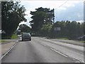
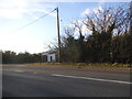
5
Bus stop on Oxford Road
The road on the left leads to Upton.
Image: © Steve Daniels
Taken: 25 May 2014
0.18 miles
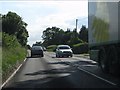
7
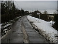
Upton Road
Upton Road entering the village
Image: © Shaun Ferguson
Taken: 9 Feb 2009
0.19 miles
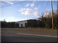
9

Fields at Lower Farm, Upton
A view south eastwards with the Chiltern Hills on the horizon.
Image: © Des Blenkinsopp
Taken: 15 Feb 2019
0.21 miles