IMAGES TAKEN NEAR TO
Oxford Road, AYLESBURY, HP17 8TU
Introduction
This page details the photographs taken nearby to Oxford Road, HP17 8TU by members of the Geograph project.
The Geograph project started in 2005 with the aim of publishing, organising and preserving representative images for every square kilometre of Great Britain, Ireland and the Isle of Man.

There are currently over 7.5m images from over14,400 individuals and you can help contribute to the project by visiting https://www.geograph.org.uk
Image Map
Images are licensed for reuse under creativecommons.org/licenses/by-sa/2.0
Notes
- Clicking on the map will re-center to the selected point.
- The higher the marker number, the further away the image location is from the centre of the postcode.
Image Listing (14 Images Found)
Images are licensed for reuse under creativecommons.org/licenses/by-sa/2.0
Image
Details
Distance
2
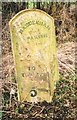
Old Milepost by the A418 in Dinton
Cast iron post by the A418, in parish of Haddenham (Aylesbury Vale District), Aylesbury Road; Haddenham Low, opposite Horridge Meadow bungalow, 100m past Westlington House, close to telegraph pole, on grass verge between road and ditch and hedge, on South side of road. Seymour iron casting, erected by the Aylesbury, Thame, Oxford & Shillingford turnpike trust in the 19th century.
Inscription reads:-
: TO / THAME / 5 : : HADDENHAM / PARISH : : TO / AYLES- / -BURY / 5 :
Maker:-
: SEYMOUR / AYLESBURY. :
Buckinghamshire HER.
HER Number: 1417900000 https://www.heritagegateway.org.uk/Gateway/Results_Single.aspx?uid=MBC26559&resourceID=1024
Milestone Society National ID: BU_AYTH05
Image: © A Rosevear & J Higgins
Taken: 24 Feb 2002
0.11 miles
3
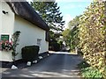
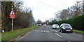
Gibraltar, Bucks
This little group of buildings is called Gibraltar - and the thatched cottage on the left is known as "The Cottage at Gibraltar" as the little green sign says. There was also a Greene King pub here, at this lane's junction with the main A418. It was called "The Bottle and Glass" (though I seem to recall that it was at one time called "The Gibraltar", but I may be misremembering).At present however it is certainly not serving any ale (see Image]). This lane runs alongside the former pub and leads to a few more cottages.
Image: © Rob Farrow
Taken: 24 Sep 2006
0.18 miles
4
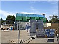
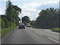
The Bottle & Glass, Gibraltar
This building was a Greene King pub called "The Bottle & Glass" at Gibraltar on the A418 southwest of Aylesbury. It is currently being virtually rebuilt - and by the looks of it considerably extended. As (from the signs) Greene King seem to be involved in the redevelopment, then hopefully it will re-open as a pub once more. I'll try to remember to take another photo of it once it has been completed.
[Edit] I'm pleased to report that it's now fully refurbished - see Image]
Image: © Rob Farrow
Taken: 24 Sep 2006
0.18 miles
5
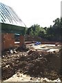
Reconstruction work, Gibraltar, Bucks
This is the view of the rear of the former Bottle & Glass P.H. at Gibraltar on the A418 between Aylesbury and Thame. As can be seen the existing building has been gutted and the foundations of a very large extension can be seen to the rear of the photo. See also Image]
Image: © Rob Farrow
Taken: 24 Sep 2006
0.18 miles
10
The entrance to Foxglove Farm, Westlington
Image: © David Howard
Taken: 11 Feb 2018
0.19 miles