IMAGES TAKEN NEAR TO
Bishopstone Road, AYLESBURY, HP17 8QR
Introduction
This page details the photographs taken nearby to Bishopstone Road, HP17 8QR by members of the Geograph project.
The Geograph project started in 2005 with the aim of publishing, organising and preserving representative images for every square kilometre of Great Britain, Ireland and the Isle of Man.

There are currently over 7.5m images from over14,400 individuals and you can help contribute to the project by visiting https://www.geograph.org.uk
Image Map
Images are licensed for reuse under creativecommons.org/licenses/by-sa/2.0
Notes
- Clicking on the map will re-center to the selected point.
- The higher the marker number, the further away the image location is from the centre of the postcode.
Image Listing (7 Images Found)
Images are licensed for reuse under creativecommons.org/licenses/by-sa/2.0
Image
Details
Distance
1
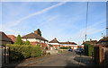
Bittenham Close, Stone
A short, residential no through road south of the main village.
Image: © Des Blenkinsopp
Taken: 23 Nov 2015
0.05 miles
2
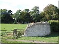
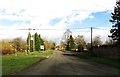
Old wall near Stone House
To the southeast of Stone on the road to Bishopstone is Stone House which can just be seen through the trees in this photograph. The massive stone wall, which starts at this gateway, runs for a good 100 yards along the lane here in front of the house.
Image: © Rob Farrow
Taken: 24 Sep 2006
0.10 miles
3
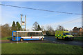
Bus & Ambulance
One for the Road Transport tag at the crossroads here.
Image: © Des Blenkinsopp
Taken: 23 Nov 2015
0.10 miles
4
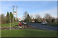
At The Crossroads
The same place as Image without the vehicle interest, unless you like bicycles.
Image: © Des Blenkinsopp
Taken: 23 Nov 2015
0.10 miles
5
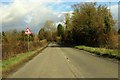
Ford Road to Aylesbury
Bishopstone Road crosses Ford Road.
Image: © Steve Daniels
Taken: 13 Feb 2014
0.11 miles
7

Autumn Bonfire
A seasonal picture in a garden near Stone.
Image: © Des Blenkinsopp
Taken: 23 Nov 2015
0.19 miles