IMAGES TAKEN NEAR TO
Sedrup, AYLESBURY, HP17 8QN
Introduction
This page details the photographs taken nearby to Sedrup, HP17 8QN by members of the Geograph project.
The Geograph project started in 2005 with the aim of publishing, organising and preserving representative images for every square kilometre of Great Britain, Ireland and the Isle of Man.

There are currently over 7.5m images from over14,400 individuals and you can help contribute to the project by visiting https://www.geograph.org.uk
Image Map
Images are licensed for reuse under creativecommons.org/licenses/by-sa/2.0
Notes
- Clicking on the map will re-center to the selected point.
- The higher the marker number, the further away the image location is from the centre of the postcode.
Image Listing (11 Images Found)
Images are licensed for reuse under creativecommons.org/licenses/by-sa/2.0
Image
Details
Distance
2
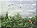
Benchmark on the chimney breast of 'Undine', Sedrup Lane
Ordnance Survey cut mark benchmark described on the Bench Mark Database at http://www.bench-marks.org.uk/bm35864
Image: © Roger Templeman
Taken: 29 Oct 2010
0.04 miles
3
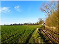
Pasture, Stone
A footpath follows the edge of this field whilst there's a bridleway immediately to the right.
Image: © Andrew Smith
Taken: 6 Dec 2014
0.07 miles
5
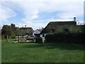
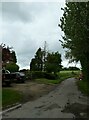
Sedrup cottages
These quaint thatched cottages are at the end of the no-through-road lane which leads to Sedrup.
Image: © Rob Farrow
Taken: 24 Sep 2006
0.09 miles
6
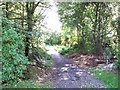
Long Distance Path, Sedrup
The drivable lane from Hartwell to Sedrup continues as a bridleway and long distance path. In fact it is simultaneously two LDPs - The Midshires Way and the North Buckinghamshire Way.
Image: © Rob Farrow
Taken: 24 Sep 2006
0.09 miles
7
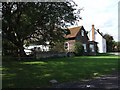
Sedrup
Where the lane to Sedrup comes to a dead end, there are the cottages shown in Image] and these. There are a few other properties that make up the hamlet of Sedrup, such as Image]
Image: © Rob Farrow
Taken: 24 Sep 2006
0.09 miles
8
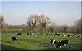
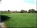
Cows at Sedrup
There are a lot of hills and hollows in this field, just like those deserted medieval village sites.
But there's nothing marked on the map.
Image: © Des Blenkinsopp
Taken: 23 Nov 2015
0.11 miles
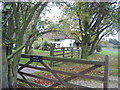
9
Sedrup Farmhouse
Taken across the gridline from near to Image
Image: © Rob Farrow
Taken: 24 Sep 2006
0.12 miles
10
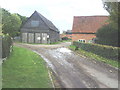
Roads into Calley Farm, Sedrup Lane
Image: © Roger Templeman
Taken: 29 Oct 2010
0.19 miles