IMAGES TAKEN NEAR TO
Oxford Road, AYLESBURY, HP17 8QG
Introduction
This page details the photographs taken nearby to Oxford Road, HP17 8QG by members of the Geograph project.
The Geograph project started in 2005 with the aim of publishing, organising and preserving representative images for every square kilometre of Great Britain, Ireland and the Isle of Man.

There are currently over 7.5m images from over14,400 individuals and you can help contribute to the project by visiting https://www.geograph.org.uk
Image Map
Images are licensed for reuse under creativecommons.org/licenses/by-sa/2.0
Notes
- Clicking on the map will re-center to the selected point.
- The higher the marker number, the further away the image location is from the centre of the postcode.
Image Listing (6 Images Found)
Images are licensed for reuse under creativecommons.org/licenses/by-sa/2.0
Image
Details
Distance
2
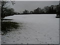
Snowy field by The Oaks
Off Oxford Road snowy field by The Oaks
Image: © Shaun Ferguson
Taken: 9 Feb 2009
0.09 miles
3
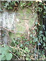
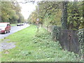
Benchmark on wall at gateway on Oxford Road
Ordnance Survey cut mark benchmark described on the Bench Mark Database at http://www.bench-marks.org.uk/bm35865. A general view of location is at Image
Image: © Roger Templeman
Taken: 29 Oct 2010
0.12 miles
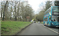
4
View along Oxford Road (A418) with gateway in the stone wall
An Arriva service 280 bus approaches on the way from Oxford Station to Aylesbury.
Image: © Roger Templeman
Taken: 29 Oct 2010
0.13 miles
5
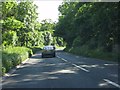
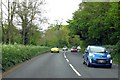
Leafy Buckinghamshire
The A418 (Oxford Road) a short distance south of Aylesbury's urban sprawl.
Image: © Peter Whatley
Taken: 19 Jun 2012
0.15 miles