IMAGES TAKEN NEAR TO
Darvill Road, AYLESBURY, HP17 8PU
Introduction
This page details the photographs taken nearby to Darvill Road, HP17 8PU by members of the Geograph project.
The Geograph project started in 2005 with the aim of publishing, organising and preserving representative images for every square kilometre of Great Britain, Ireland and the Isle of Man.

There are currently over 7.5m images from over14,400 individuals and you can help contribute to the project by visiting https://www.geograph.org.uk
Image Map
Images are licensed for reuse under creativecommons.org/licenses/by-sa/2.0
Notes
- Clicking on the map will re-center to the selected point.
- The higher the marker number, the further away the image location is from the centre of the postcode.
Image Listing (5 Images Found)
Images are licensed for reuse under creativecommons.org/licenses/by-sa/2.0
Image
Details
Distance
1
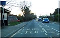
Oxford Road leaving Stone
The A418 runs from Aylesbury to Thame.
Image: © Steve Daniels
Taken: 13 Feb 2014
0.04 miles
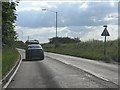
2

Oxford Road (A418)
Oxford Road (A418) entering Stone heading towards Aylesbury
Image: © Shaun Ferguson
Taken: 9 Feb 2009
0.05 miles
3

Closed chapel, Stone
This is the former chapel to the mental hospital which once covered several acres in this and adjoining squares. The hospital closed and has now vanished; the site now full of modern houses. Only this rather unremarkable Victorian chapel remains - the demolished hospital having been of far greater architectural interest. A sign says that there are plans to convert it into three dwellings. Let's hope there are no ghosts from its former life !
Image: © Rob Farrow
Taken: 24 Sep 2006
0.11 miles
5
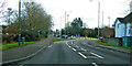
A418 Oxford Road, Stone
Towards Aylesbury.
Image: © Robin Webster
Taken: 8 Dec 2019
0.18 miles