IMAGES TAKEN NEAR TO
Westland Close, AYLESBURY, HP17 8FJ
Introduction
This page details the photographs taken nearby to Westland Close, HP17 8FJ by members of the Geograph project.
The Geograph project started in 2005 with the aim of publishing, organising and preserving representative images for every square kilometre of Great Britain, Ireland and the Isle of Man.

There are currently over 7.5m images from over14,400 individuals and you can help contribute to the project by visiting https://www.geograph.org.uk
Image Map (Loading...)


Getting Data...Please wait
Leaflet Map data © OpenStreetMap
Images are licensed for reuse under creativecommons.org/licenses/by-sa/2.0
Notes
- Clicking on the map will re-center to the selected point.
- The higher the marker number, the further away the image location is from the centre of the postcode.
Image Listing (4 Images Found)
Images are licensed for reuse under creativecommons.org/licenses/by-sa/2.0
Image
Details
Distance
3
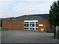
Telephone Exchange, Haddenham, Bucks
Situated in Dollicott, this building which dates from the early 1970s, replaced the old exchange in Crabtree Road, now a private dwelling. It has the code SMHDM and provides telephone and broadband services to 2,272 residential and 123 non-residential premises in Haddenham plus Aston Sandford, Cuddington, Kingsey and Nether Winchendon nearby. The numbering range of this new TE is (01844) 29xxxx, the (01844) referring to the Thame group of nine TEs, and its postcode is HP17 8JG.
Image: © David Hillas
Taken: 29 Aug 2008
0.23 miles
4

Haddenham Business Park
This is part of the site of Haddenham airfield. When the photo was taken heavy clouds were threatening rain, which followed about ten minutes later.
Image: © David Hawgood
Taken: 25 Aug 2005
0.23 miles