IMAGES TAKEN NEAR TO
Sheerstock, AYLESBURY, HP17 8EY
Introduction
This page details the photographs taken nearby to Sheerstock, HP17 8EY by members of the Geograph project.
The Geograph project started in 2005 with the aim of publishing, organising and preserving representative images for every square kilometre of Great Britain, Ireland and the Isle of Man.

There are currently over 7.5m images from over14,400 individuals and you can help contribute to the project by visiting https://www.geograph.org.uk
Image Map
Images are licensed for reuse under creativecommons.org/licenses/by-sa/2.0
Notes
- Clicking on the map will re-center to the selected point.
- The higher the marker number, the further away the image location is from the centre of the postcode.
Image Listing (13 Images Found)
Images are licensed for reuse under creativecommons.org/licenses/by-sa/2.0
Image
Details
Distance
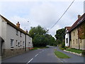
1
Sheerstock, Haddenham
Sheerstock is the name of the road, perhaps a marketing ploy to lull residents into thinking their housing estate is a countryside idyll.
Image: © David Sands
Taken: 17 Aug 2007
0.06 miles
2
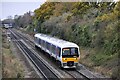
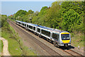
Site of old Haddenham Station
DMU No. 165038 has just left Haddenham & Thame Parkway Station with the 1113 departure from Banbury to Marylebone, whilst No.168216 is entering the station with the 1116 departure from Marylebone to Birmingham Snow Hill.
Image: © Bob Walters
Taken: 10 Nov 2021
0.09 miles
3
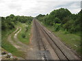
Haddenham railway station (site), Buckinghamshire
Opened in 1906 by the Great Western Railway on the line from London Marylebone to Banbury via Bicester, this station closed to passengers in 1963.
View north west towards Haddenham & Thame Parkway (just beyond the next bridge) and Bicester.
Image: © Nigel Thompson
Taken: 7 Jun 2014
0.12 miles
4
Railway at Haddenham
Passenger train passing Haddenham.
Image: © Wayland Smith
Taken: 6 May 2018
0.13 miles
5
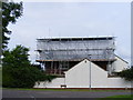
Bolt from the Sky
This house in Slave Hill, Haddenham (there's no hill here, by the way) lost its roof due to a severe lightning strike, and is shown undergoing repairs.
Image: © David Sands
Taken: 17 Aug 2007
0.16 miles
6
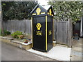
AA Telephone Box in Haddenham, Bucks
Situated in Greenway HP17 8BJ, this telephone box 398 used to be located at the junction of the A167 and B1264 roads at Entercommon in North Yorkshire, NZ3305 refers. It is gratifying that it has found a resting place in the village of Haddenham, Bucks.
Image: © David Hillas
Taken: 6 May 2019
0.17 miles
7
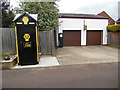
AA Telephone Box and disused Garage in Haddenham, Bucks
This photo shows the AA box 398 and the former garage in Greenway HP17 8BJ. To the left of the garage can be seen an old petrol pump whilst in the middle is an old AA garage sign. It is hoped that both the AA box and garage will be listed if they haven't already been done so.
Image: © David Hillas
Taken: 6 May 2019
0.18 miles
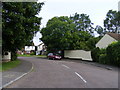
8
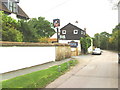
View south along Townside past the Kings Head
Image: © Roger Templeman
Taken: 13 Sep 2010
0.20 miles
9
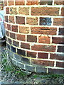
Benchmark on #45 Townside
Ordnance Survey cut mark benchmark described on the Bench Mark Database at http://www.bench-marks.org.uk/bm35525.
Image: © Roger Templeman
Taken: 13 Sep 2010
0.20 miles