IMAGES TAKEN NEAR TO
High Street, AYLESBURY, HP17 8ET
Introduction
This page details the photographs taken nearby to High Street, HP17 8ET by members of the Geograph project.
The Geograph project started in 2005 with the aim of publishing, organising and preserving representative images for every square kilometre of Great Britain, Ireland and the Isle of Man.

There are currently over 7.5m images from over14,400 individuals and you can help contribute to the project by visiting https://www.geograph.org.uk
Image Map (Loading...)


Getting Data...Please wait
Leaflet Map data © OpenStreetMap
Images are licensed for reuse under creativecommons.org/licenses/by-sa/2.0
Notes
- Clicking on the map will re-center to the selected point.
- The higher the marker number, the further away the image location is from the centre of the postcode.
Image Listing (27 Images Found)
Images are licensed for reuse under creativecommons.org/licenses/by-sa/2.0
Image
Details
Distance
1
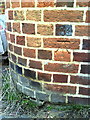
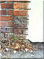
Benchmark on #45 Townside
Ordnance Survey cut mark benchmark described on the Bench Mark Database at http://www.bench-marks.org.uk/bm35525.
Image: © Roger Templeman
Taken: 13 Sep 2010
0.03 miles
2
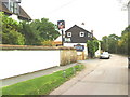
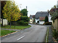
View south along Townside past the Kings Head
Image: © Roger Templeman
Taken: 13 Sep 2010
0.03 miles
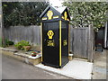
3
AA Telephone Box and disused Garage in Haddenham, Bucks
This photo shows the AA box 398 and the former garage in Greenway HP17 8BJ. To the left of the garage can be seen an old petrol pump whilst in the middle is an old AA garage sign. It is hoped that both the AA box and garage will be listed if they haven't already been done so.
Image: © David Hillas
Taken: 6 May 2019
0.06 miles
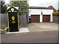
4
AA Telephone Box in Haddenham, Bucks
Situated in Greenway HP17 8BJ, this telephone box 398 used to be located at the junction of the A167 and B1264 roads at Entercommon in North Yorkshire, NZ3305 refers. It is gratifying that it has found a resting place in the village of Haddenham, Bucks.
Image: © David Hillas
Taken: 6 May 2019
0.08 miles
5
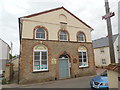
Haddenham Methodist Church
Situated in High Street HP17 8ES, this Methodist church dates from 1822 and is said to be the tallest Witchert building in the world, Witchert being a mixture of white chalk and clay. It is one of seventeen churches in the Vale of Aylesbury Methodist Circuit. Services are held here each Sunday at 10.15am whilst activities take place during the week. To the left of the entrance door can be seen a notice that says "ALL VISITORS VERY WELCOME". Also, on a telegraph pole to the right of the photo is an arrow pointing towards that church across the road.
Image: © David Hillas
Taken: 6 May 2019
0.09 miles
7
Benchmark on #2 Crabtree Road
Ordnance Survey cut mark benchmark
Image: © Roger Templeman
Taken: 13 Sep 2010
0.17 miles
9
Skittles Green, Haddenham, Buckinghamshire
Image: © Oswald Bertram
Taken: 9 Jul 2015
0.19 miles
10
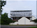
Bolt from the Sky
This house in Slave Hill, Haddenham (there's no hill here, by the way) lost its roof due to a severe lightning strike, and is shown undergoing repairs.
Image: © David Sands
Taken: 17 Aug 2007
0.19 miles