1
Haddenham Methodist Church
Situated in High Street HP17 8ES, this Methodist church dates from 1822 and is said to be the tallest Witchert building in the world, Witchert being a mixture of white chalk and clay. It is one of seventeen churches in the Vale of Aylesbury Methodist Circuit. Services are held here each Sunday at 10.15am whilst activities take place during the week. To the left of the entrance door can be seen a notice that says "ALL VISITORS VERY WELCOME". Also, on a telegraph pole to the right of the photo is an arrow pointing towards that church across the road.
Image: © David Hillas
Taken: 6 May 2019
0.06 miles
2
Benchmark on #2 Crabtree Road
Ordnance Survey cut mark benchmark
Image: © Roger Templeman
Taken: 13 Sep 2010
0.10 miles
3
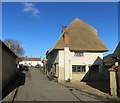
New Thatch in Haddenham
This is Haddenham High Street, very narrow and quiet compared to most.
Image: © Des Blenkinsopp
Taken: 17 Feb 2015
0.14 miles
4
Benchmark on #45 Townside
Ordnance Survey cut mark benchmark described on the Bench Mark Database at http://www.bench-marks.org.uk/bm35525.
Image: © Roger Templeman
Taken: 13 Sep 2010
0.15 miles
5
View south along Townside past the Kings Head
Image: © Roger Templeman
Taken: 13 Sep 2010
0.16 miles
6
The Gables, Haddenham
Image: © Des Blenkinsopp
Taken: 17 Feb 2015
0.16 miles
7
AA Telephone Box and disused Garage in Haddenham, Bucks
This photo shows the AA box 398 and the former garage in Greenway HP17 8BJ. To the left of the garage can be seen an old petrol pump whilst in the middle is an old AA garage sign. It is hoped that both the AA box and garage will be listed if they haven't already been done so.
Image: © David Hillas
Taken: 6 May 2019
0.16 miles
8
Haddenham: Towards Church End
Image: © Ed Andrews
Taken: 14 Jul 2008
0.17 miles
9
AA Telephone Box in Haddenham, Bucks
Situated in Greenway HP17 8BJ, this telephone box 398 used to be located at the junction of the A167 and B1264 roads at Entercommon in North Yorkshire, NZ3305 refers. It is gratifying that it has found a resting place in the village of Haddenham, Bucks.
Image: © David Hillas
Taken: 6 May 2019
0.17 miles
10
Bus at The House Of Spice
What looks to have been a large pub is now a large Indian Restaurant.
Let's hope curry succeeds where beer failed.
Image: © Des Blenkinsopp
Taken: 17 Feb 2015
0.18 miles


