IMAGES TAKEN NEAR TO
Marriotts Avenue, GREAT MISSENDEN, HP16 9QN
Introduction
This page details the photographs taken nearby to Marriotts Avenue, HP16 9QN by members of the Geograph project.
The Geograph project started in 2005 with the aim of publishing, organising and preserving representative images for every square kilometre of Great Britain, Ireland and the Isle of Man.

There are currently over 7.5m images from over14,400 individuals and you can help contribute to the project by visiting https://www.geograph.org.uk
Image Map
Images are licensed for reuse under creativecommons.org/licenses/by-sa/2.0
Notes
- Clicking on the map will re-center to the selected point.
- The higher the marker number, the further away the image location is from the centre of the postcode.
Image Listing (6 Images Found)
Images are licensed for reuse under creativecommons.org/licenses/by-sa/2.0
Image
Details
Distance
1
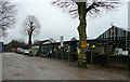
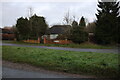
South Heath Garden Centre
Tucked away in a village straight out of Enid Blyton is this traditional nursery business.
Image: © Jonathan Billinger
Taken: 28 Mar 2008
0.12 miles
2
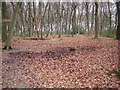
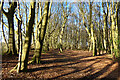
South Heath: Redding Wick
A footpath through the wood viewed looking eastwards.
Image: © Nigel Cox
Taken: 2 Jan 2006
0.20 miles
4
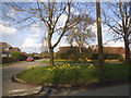
King's Lane at the junction of Lappetts Lane
The house replaced a bungalow a few years earlier.
Image: © David Howard
Taken: 14 Apr 2018
0.23 miles
6
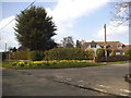
Woodland, Great Missenden
Beeches in a publicly accessible wood to the east of South Heath.
Image: © Andrew Smith
Taken: 2 Apr 2023
0.23 miles