IMAGES TAKEN NEAR TO
Lee Common, GREAT MISSENDEN, HP16 9NB
Introduction
This page details the photographs taken nearby to HP16 9NB by members of the Geograph project.
The Geograph project started in 2005 with the aim of publishing, organising and preserving representative images for every square kilometre of Great Britain, Ireland and the Isle of Man.

There are currently over 7.5m images from over14,400 individuals and you can help contribute to the project by visiting https://www.geograph.org.uk
Image Map
Images are licensed for reuse under creativecommons.org/licenses/by-sa/2.0
Notes
- Clicking on the map will re-center to the selected point.
- The higher the marker number, the further away the image location is from the centre of the postcode.
Image Listing (12 Images Found)
Images are licensed for reuse under creativecommons.org/licenses/by-sa/2.0
Image
Details
Distance
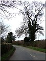
1

Signpost in Lee Clump Road
This photo shows the signpost pointing towards the Parish Hall and Shop at The Lee, https://www.geograph.org.uk/photo/6943422 refers. A sign below the signpost indicates that the Shop is open.
Image: © David Hillas
Taken: 20 Aug 2021
0.12 miles
2
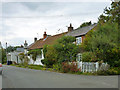
Cottages, Lee Common
At the far end, set back so mostly hidden, is a former pub, The Bugle. Set forward beyond it and apparently part of the same enterprise is what looks like a former shop.
Image: © Robin Webster
Taken: 21 Sep 2014
0.12 miles
3
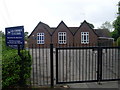
Lee Common CE School, Bucks
Founded in 1873, this school is situated in Oxford Street, Lee Common, HP16 9JH.
Image: © David Hillas
Taken: 16 May 2009
0.12 miles
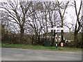
4
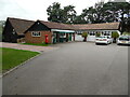
Scout Hut, Parish Hall and the Shop, The Lee
Situated in Lee Clump Road HP16 9NB, these buildings are from left to right: Lee Common Scout Hut, the Shop at The Lee, and The Lee Parish Hall. A red post box can be seen by the Shop at The Lee.
Image: © David Hillas
Taken: 20 Aug 2021
0.12 miles
5
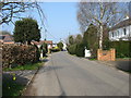
Lee Common
A view of the main street.
Image: © David Purchase
Taken: 9 Apr 2015
0.15 miles
6
Fantastical Oak, Gwenfa
In the absence of leaves (other than the ivy covering it) I am assuming that this is an oak from its shape. If I remember to, I'll check later in the year !
Image: © Rob Farrow
Taken: 19 Apr 2006
0.16 miles
7
Former Lee Common Methodist Church, Bucks
Dating from 1839, this Primitive Methodist Chapel is situated in Oxford Street, Lee Common. Its postcode is HP16 9JP. Update: the closing service at this church was held at 3.00pm on Sunday 22nd August 2021.
Image: © David Hillas
Taken: 16 May 2009
0.19 miles
8
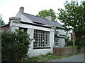
The Bugle, Lee Common
This pub was always, let's say "idiosyncratically" run. Sadly it's currently not open. Maybe one day Lee Common will have a pub again.
Image: © Rob Farrow
Taken: 10 May 2006
0.22 miles
9
Not Inn !
The only reason I'm posting this rather boring shot is that according to the 1940s map there used to be an inn on this spot. It seems to have vanished without trace - perhaps it was a 1940s "Easter Egg". The building behind the hedge is either Gwenfa Farm (according to the map) or Gwenfa Fields (according to a local sign) - or perhaps they're both lurking there.
A bit of research (from a map of c.1890) shows that there was a pub (or presumably an inn) nearby at SP90730491 called The Red Lion. [Edit May 08] I have been informed that 100 yards to the left of this sign is "Red Lion House" which was the former pub.
Image: © Rob Farrow
Taken: 19 Apr 2006
0.22 miles
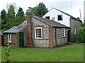
10
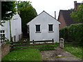
The Lee Telephone Exchange, Bucks
This white-painted building is situated in Oxford Street, Lee Common, HP16 9JP and has the exchange code SMTL. It provides telephone and broadband services to 429 residential and 28 non-residential premises in Lee Common plus Ballinger (part), Kings Ash, Lee Gate, Swan Bottom and The Lee nearby. Its numbering range is (01494) 837xxx, the (01494) referring to the High Wycombe group of sixteen TEs. Not to be confused with the well-known shopping street in Central London.
Image: © David Hillas
Taken: 14 Jul 2008
0.23 miles