1
Old Milestone by the former A413 in Great Missenden
Carved stone post by the UC road (was A413), in parish of Great Missenden (Chiltern District), Aylesbury Road; Old Town Farm, by No. 12, Milestone Cottage, on cut grass behind footpath, by junction, on West side of road. Amersham limestone square, erected by the Wendover & Oak Lane turnpike trust in the 18th century.
Inscription reads:-
LONDON
31
Carved benchmark on lower front face.
Buckinghamshire HER.
HER Number: 1351800000 https://www.heritagegateway.org.uk/Gateway/Results_Single.aspx?uid=MBC25342&resourceID=1024
Milestone Society National ID: BU_LC31
Image: © A Rosevear
Taken: 1 Nov 2004
0.02 miles
2
"The White Lion" public house
Image: © Jim Osley
Taken: 7 Aug 2014
0.04 miles
3
Flowers in Walnut Close, Great Missenden
This photo shows a small carpet of daffodils and primroses in Walnut Close, HP16 9AL. They come out in March every year and are a sign that Spring has arrived.
Image: © David Hillas
Taken: 20 Mar 2021
0.04 miles
4
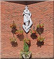
Madonna and Child, Great Missenden
On the exterior of The Immaculate Heart of Mary Roman Catholic Church (built 1964)
Image: © Jim Osley
Taken: 7 Aug 2014
0.06 miles
5
Roman Catholic Church, Great Missenden
Situated in High Street HP16 9AA, this Catholic Church Immaculate Heart of Mary, to give it its full name, dates from 1964. Services take place here daily. The Abbeyfield House in Link Road can be seen to the right of the photo.
Image: © David Hillas
Taken: 18 Jun 2012
0.07 miles
6
View of Great Missenden from Boug's Meadow
This photo, taken from Boug's Meadow, is looking west towards Great Missenden with the Link Road Car Park behind the hedge. In the distance can be seen the Roman Catholic Church on the left, while in the middle are houses in Walnut Close. To the right of the photo, apartments in Elmtree Green can just be seen. In front of the hedge is the River Misbourne although it isn't visible in this photo.
Image: © David Hillas
Taken: 20 Mar 2021
0.07 miles
7
Electricity Sub-Station, Great Missenden
This sub-station is situated behind the car park in Link Road, Great Missenden. This photo was taken behind the tall metal gateway.
Image: © David Hillas
Taken: 11 May 2010
0.07 miles
8
Roundabout on the A413, Great Missenden
Image: © David Howard
Taken: 4 Oct 2011
0.08 miles
9
"Walks in the Misbourne Valley" Notice
This notice is located at the entrance to the Link Road car park in Great Missenden. It says the following:
The River Misbourne - a "winterbourne"
Running alongside this car park is the course of the River Misbourne. Its source lies about 1km north of here, near Mobwell Pond, and it meanders down to Denham where it joins the River Colne 17miles/27km away. The Misbourne is special because it is a chalk stream - an internationally rare wildlife habitat.
Chalk streams are mostly fed from groundwater rather than surface run-off. The underlying chalk soaks up water like a sponge. This water bearing rock is called an "aquifer". Groundwater emerges from it as springs to feed the streams. Since groundwater levels in the aquifer fluctuate according to rainfall, chalk streams are naturally intermittent in their flow.
The upper section of the Misbourne is especially prone to drying up and is called a winterbourne. This section of the river only flows after heavy winter rain has recharged the chalk aquifer, causing groundwater levels to rise.
Seasonal changes in a winterbourne stream.
In winter
The water table will be at its highest after winter rainfall.
In summer
The water table drops through the summer as there is less rainfall and increased uptake by plants.
Rescuing the River
The River Misbourne is a valuable local resource for many reasons including wildlife, water and recreation. The chalk acts as a superb filter for rainwater and produces very pure and healthy drinking water. As the local population grew over the 20th century, so water abstraction from the aquifer increased. This lowered the water table and caused the flow of the river between here and Chalfont St Peter to become highly intermittent. In drought years the river virtually dried up.
A River Rescue Scheme began in 1997. Abstraction of groundwater from pumping stations along the valley was reduced, allowing groundwater levels to recover naturally.
Three Circular Walks
Three circular walks have been created to celebrate the river's recovery. Walk 1 starts from here and loops around Great Missenden. You can pick up the "Walks in the Misbourne Valley" leaflet from local public information points, including the Library and Parish Council Office in Great Missenden.
Images of Mobwell Pond, Church of St Peter and Paul and Missenden Abbey can be seen on the noticeboard together with a plan of the River Misbourne with its three walks indicated on it.
Image: © David Hillas
Taken: 27 Apr 2016
0.08 miles
10
New buildings on Martinsend Lane, Great Missenden
The work is continuing, the Hampton's building on the left has had two new floors built above it starting around a year ago. The ground floor is original.
Image: © David Howard
Taken: 14 Apr 2018
0.08 miles


