IMAGES TAKEN NEAR TO
High Street, GREAT MISSENDEN, HP16 9AA
Introduction
This page details the photographs taken nearby to High Street, HP16 9AA by members of the Geograph project.
The Geograph project started in 2005 with the aim of publishing, organising and preserving representative images for every square kilometre of Great Britain, Ireland and the Isle of Man.

There are currently over 7.5m images from over14,400 individuals and you can help contribute to the project by visiting https://www.geograph.org.uk
Image Map
Images are licensed for reuse under creativecommons.org/licenses/by-sa/2.0
Notes
- Clicking on the map will re-center to the selected point.
- The higher the marker number, the further away the image location is from the centre of the postcode.
Image Listing (109 Images Found)
Images are licensed for reuse under creativecommons.org/licenses/by-sa/2.0
Image
Details
Distance
1
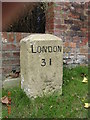
Old Milestone by the former A413 in Great Missenden
Carved stone post by the UC road (was A413), in parish of Great Missenden (Chiltern District), Aylesbury Road; Old Town Farm, by No. 12, Milestone Cottage, on cut grass behind footpath, by junction, on West side of road. Amersham limestone square, erected by the Wendover & Oak Lane turnpike trust in the 18th century.
Inscription reads:-
LONDON
31
Carved benchmark on lower front face.
Buckinghamshire HER.
HER Number: 1351800000 https://www.heritagegateway.org.uk/Gateway/Results_Single.aspx?uid=MBC25342&resourceID=1024
Milestone Society National ID: BU_LC31
Image: © A Rosevear
Taken: 1 Nov 2004
0.05 miles
2
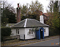
Great Missenden Tollhouse by Aylesbury Road, Great Missenden
In the parish of Great Missenden (Chiltern District), The Old Toll House, Aylesbury Road, HP16 9AX.
Grade II listed.
List Entry Number: 1124807 https://historicengland.org.uk/listing/the-list/list-entry/1124807
Surveyed
Milestone Society National ID: BU.GRE
Image: © Alan Rosevear
Taken: 1 Nov 2005
0.07 miles

5
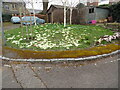
Flowers in Walnut Close, Great Missenden
This photo shows a small carpet of daffodils and primroses in Walnut Close, HP16 9AL. They come out in March every year and are a sign that Spring has arrived.
Image: © David Hillas
Taken: 20 Mar 2021
0.08 miles
6

Madonna and Child, Great Missenden
On the exterior of The Immaculate Heart of Mary Roman Catholic Church (built 1964)
Image: © Jim Osley
Taken: 7 Aug 2014
0.10 miles
7
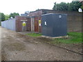
Electricity Sub-Station, Great Missenden
This sub-station is situated behind the car park in Link Road, Great Missenden. This photo was taken behind the tall metal gateway.
Image: © David Hillas
Taken: 11 May 2010
0.11 miles
8

Roman Catholic Church, Great Missenden
Situated in High Street HP16 9AA, this Catholic Church Immaculate Heart of Mary, to give it its full name, dates from 1964. Services take place here daily. The Abbeyfield House in Link Road can be seen to the right of the photo.
Image: © David Hillas
Taken: 18 Jun 2012
0.11 miles
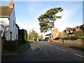
9
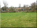
View of Great Missenden from Boug's Meadow
This photo, taken from Boug's Meadow, is looking west towards Great Missenden with the Link Road Car Park behind the hedge. In the distance can be seen the Roman Catholic Church on the left, while in the middle are houses in Walnut Close. To the right of the photo, apartments in Elmtree Green can just be seen. In front of the hedge is the River Misbourne although it isn't visible in this photo.
Image: © David Hillas
Taken: 20 Mar 2021
0.11 miles
10
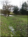
River Misbourne near Mobwell (1)
This photo shows the River Misbourne looking south between Mobwell and Great Missenden.
Image: © Christina Hillas
Taken: 23 Feb 2020
0.11 miles