IMAGES TAKEN NEAR TO
Hyde End, GREAT MISSENDEN, HP16 0RJ
Introduction
This page details the photographs taken nearby to HP16 0RJ by members of the Geograph project.
The Geograph project started in 2005 with the aim of publishing, organising and preserving representative images for every square kilometre of Great Britain, Ireland and the Isle of Man.

There are currently over 7.5m images from over14,400 individuals and you can help contribute to the project by visiting https://www.geograph.org.uk
Image Map
Images are licensed for reuse under creativecommons.org/licenses/by-sa/2.0
Notes
- Clicking on the map will re-center to the selected point.
- The higher the marker number, the further away the image location is from the centre of the postcode.
Image Listing (7 Images Found)
Images are licensed for reuse under creativecommons.org/licenses/by-sa/2.0
Image
Details
Distance
1
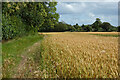
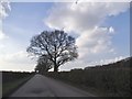
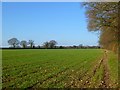
Farmland, Little Missenden
Wheat to the north-west of Hyde Heath.
Image: © Andrew Smith
Taken: 15 Jul 2023
0.17 miles
3
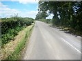
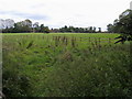
Farmland, Hyde Heath, Little Missenden
A cereal crop to the northwest of Hyde Heath. The trees to the left are on Hydeheath Road.
Image: © Andrew Smith
Taken: 15 Jan 2012
0.20 miles
4
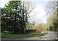
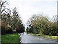
Footpath to Hawthorn Farm
Footpath off the Chesham Road to Hawthorn Farm
Image: © Shaun Ferguson
Taken: 3 Oct 2008
0.21 miles