IMAGES TAKEN NEAR TO
Cudsdens Court, GREAT MISSENDEN, HP16 0QX
Introduction
This page details the photographs taken nearby to Cudsdens Court, HP16 0QX by members of the Geograph project.
The Geograph project started in 2005 with the aim of publishing, organising and preserving representative images for every square kilometre of Great Britain, Ireland and the Isle of Man.

There are currently over 7.5m images from over14,400 individuals and you can help contribute to the project by visiting https://www.geograph.org.uk
Image Map
Images are licensed for reuse under creativecommons.org/licenses/by-sa/2.0
Notes
- Clicking on the map will re-center to the selected point.
- The higher the marker number, the further away the image location is from the centre of the postcode.
Image Listing (10 Images Found)
Images are licensed for reuse under creativecommons.org/licenses/by-sa/2.0
Image
Details
Distance
3
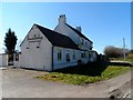
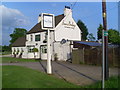
Former Restaurant, Annie Bailey's
It used to be a pub called the "Barley Mow", then it became a restaurant in 2002, now it is closed.
Image: © Bikeboy
Taken: 16 Mar 2014
0.12 miles
5
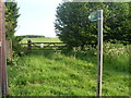
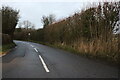
Public Footpath Sign in Chesham Road (B485)
This photo shows a public footpath sign leading into a field off Chesham Road (B485) then into Hyde Lane.
Image: © David Hillas
Taken: 30 May 2012
0.12 miles
6
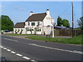
Annie Baileys, Great Missenden (2)
This photo shows the Annie Baileys restaurant and Bar in Chesham Road, HP16 0QT. Its car park can be seen on the left of the photo. Update: this restaurant and bar is now closed and its future is uncertain.
Image: © David Hillas
Taken: 30 May 2012
0.12 miles
7
Annie Baileys, Great Missenden (1)
Situated in Chesham Road (B485), this building is now a restaurant and bar. It used to be called "The Barley Mow" until a change of ownership also involved a change of name. A public footpath sign can be seen to the right of the photo.
Image: © David Hillas
Taken: 30 May 2012
0.13 miles
8
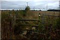
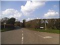
Stile on overgrown footpath
The footpath leading to this stile has been ploughed over. On the other side, the path is still discernible but not well maintained.
Image: © Robert Eva
Taken: 8 Oct 2016
0.19 miles
10
Field with path ploughed over
According to the map, there is path across this field. On the opposite side there is a stile
Image: © Robert Eva
Taken: 8 Oct 2016
0.23 miles