IMAGES TAKEN NEAR TO
Perks Lane, GREAT MISSENDEN, HP16 0JQ
Introduction
This page details the photographs taken nearby to Perks Lane, HP16 0JQ by members of the Geograph project.
The Geograph project started in 2005 with the aim of publishing, organising and preserving representative images for every square kilometre of Great Britain, Ireland and the Isle of Man.

There are currently over 7.5m images from over14,400 individuals and you can help contribute to the project by visiting https://www.geograph.org.uk
Image Map
Images are licensed for reuse under creativecommons.org/licenses/by-sa/2.0
Notes
- Clicking on the map will re-center to the selected point.
- The higher the marker number, the further away the image location is from the centre of the postcode.
Image Listing (15 Images Found)
Images are licensed for reuse under creativecommons.org/licenses/by-sa/2.0
Image
Details
Distance
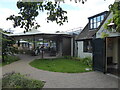
1
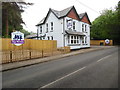
Flower Pots Day Nursery, Prestwood
Located at 188 Wycombe Road HP16 0HJ, this day nursery opened in May 2018 on the premises that was the King's Head public house for some years, http://www.geograph.org.uk/photo/1365755 refers. Two display boards and the pub sign indicate that the building is now the Flower Pots Day Nursery.
Image: © David Hillas
Taken: 26 May 2018
0.16 miles
2
Kings Head, Prestwood
Located at 188 Wycombe Road, Prestwood, HP16 0HJ, just North of Peterley Corner. Update: this public house has closed since this photo was taken, and is now the Flower Pots Day Nursery, http://www.geograph.org.uk/photo/5789174 refers .
Image: © David Hillas
Taken: 22 Jun 2009
0.17 miles
3
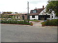
A4128 Missenden Road enters Prestwood
The former Kings Head pub ahead is now a day nursery.
Image: © Robin Webster
Taken: 9 Jun 2019
0.17 miles
4
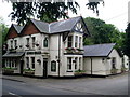
The Polecat Inn, Prestwood
Looks like a popular pub on the southern fringe of the village. The road is the A4128 which is quite quiet by A-road standards.
Image: © Andrew Smith
Taken: 17 Aug 2008
0.19 miles
5
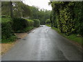
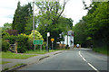
Perks Lane
Perks Lane heading to the junction with the A4128 Wycombe Road
Image: © Shaun Ferguson
Taken: 7 Sep 2008
0.19 miles
6
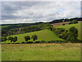
Pasture, Prestwood
Below are properties on Perks Lane. These mark the start of SU8699. This is typical Chiltern countryside.
Image: © Andrew Smith
Taken: 17 Aug 2008
0.19 miles
7
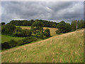
Pasture, Prestwood
A view across a small side-valley to Lawrence Grove Wood.
Image: © Andrew Smith
Taken: 17 Aug 2008
0.19 miles
8
At the Polecat Inn in Prestwood, Bucks
Recently taken over by a bijou pub chain and invested in and redeveloped to great effect. It has not lost its character. The facilities are just much improved; car park, decor, pods, outside drinking and eating areas etc. Recommended.
Image: © Jeremy Bolwell
Taken: 15 Aug 2021
0.21 miles
9
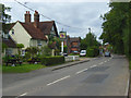
The Polecat Inn, Prestwood (2)
This photo shows the public house from the south with the recently built extension to the left. The blue notice in front of the main entrance says:
Temporary Car Park Surface
Please mind the raised kerbs
Image: © David Hillas
Taken: 6 May 2019
0.22 miles
10
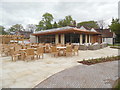
The Polecat Inn with extension, Prestwood (1)
This photo shows the recently opened extension with wooden tables and chairs in the foreground for customers to eat and drink. The original inn, which is Grade II listed, can be seen behind it.
Image: © David Hillas
Taken: 6 May 2019
0.22 miles