IMAGES TAKEN NEAR TO
Wycombe Road, GREAT MISSENDEN, HP16 0HN
Introduction
This page details the photographs taken nearby to Wycombe Road, HP16 0HN by members of the Geograph project.
The Geograph project started in 2005 with the aim of publishing, organising and preserving representative images for every square kilometre of Great Britain, Ireland and the Isle of Man.

There are currently over 7.5m images from over14,400 individuals and you can help contribute to the project by visiting https://www.geograph.org.uk
Image Map
Images are licensed for reuse under creativecommons.org/licenses/by-sa/2.0
Notes
- Clicking on the map will re-center to the selected point.
- The higher the marker number, the further away the image location is from the centre of the postcode.
Image Listing (30 Images Found)
Images are licensed for reuse under creativecommons.org/licenses/by-sa/2.0
Image
Details
Distance
1
View of Wycombe Road from Lodge Lane, Prestwood
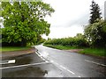
This photo shows the A4128 Wycombe Road HP16 0HN looking south from Lodge Lane which is the road to the left of the photo. An oak tree can be seen to the left of Wycombe Road. Although this photo was taken in the late afternoon, there is hardly any traffic on this road due to the Covid-19 virus lockdown being currently in force.
Image: © David Hillas
Taken: 1 May 2020
0.05 miles
3
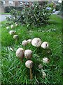
Shaggy Parasol fungus in Lodge Lane, Prestwood
This photo shows the Shaggy Parasol fungus at the west end of Lodge Lane. It is a large and conspicuous agaric with thick brown scales and protuberances on its freshy white cap. This mushroom does contain toxins which can cause gastric upsets, so it is not recommended for eating. In the background can be seen houses in Collings Walk.
Image: © David Hillas
Taken: 10 Oct 2019
0.08 miles
4
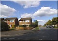
Lodge Lane
Lodge Lane heading up past Wren Road
Image: © Shaun Ferguson
Taken: 3 Oct 2008
0.10 miles
5
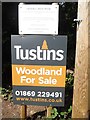
Woodland for Sale Notice by Lawrence Grove Wood
This photo shows a large notice by a gate in Wycombe Road mentioning that Lawrence Grove Wood nearby is for sale. Details of the white notice above it is as https://www.geograph.org.uk/photo/6540664 refers.
Image: © David Hillas
Taken: 12 Jul 2020
0.12 miles
6
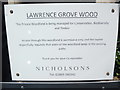
Notice by gate to Lawrence Grove Wood
This photo shows the notice which has been fixed by the gate at the entrance to Lawrence Grove Wood in Wycombe Road. It has the following wording:
LAWRENCE GROVE WOOD
This Private Woodland is being managed for Conservation, Biodiversity
and Timber
Access through this woodland is permissive only and the owner
respectfully requests that users of the woodland keep to the existing
paths
Thank you for your Co-operation
The name of the owner and telephone number are at the foot of this notice.
Image: © David Hillas
Taken: 12 Jul 2020
0.12 miles
7
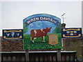
Notice Board at Collings Hanger Farm, Prestwood
This photo shows the new notice board at Collings Hanger Farm in Wycombe Road mentioning that Wren Davis Ltd had won prizes for clean milk way back in 1930. It replaced the old noticeboard that had been there for several years. Only the telephone number on the new noticeboard has changed.
Image: © David Hillas
Taken: 13 Mar 2015
0.12 miles
8
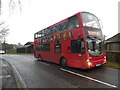
A Carousel bus in Wycombe Road, Prestwood
This bus is photographed outside Collings Hanger Farm in Wycombe Road working on route 41 to Great Missenden. It is 940 (LX05 EZO) a Volvo B7TL with Wrightbus Eclipse 64-seater bodywork. This photo compares with the one taken in the same location of Arriva bus 3923 (BK58 URR) the previous Saturday 7th January 2023, https://www.geograph.org.uk/photo/7380161 refers. Carousel Buses took over from Arriva operating this route from Monday 9th January 2023.
Image: © David Hillas
Taken: 11 Jan 2023
0.13 miles
9
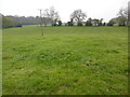
Friars Field at Collings Hanger Farm
Taken from near the A4128 Wycombe Road, this photo shows Friars Field which is part of the Wren Davis estate at Collings Hanger Farm. This field has been used in recent years for the Annual Bonfire and Firework Display held usually on the Saturday nearest to the 5th November (Guy Fawkes Day). Beyond this field can be seen the field known as The Strip.
Image: © David Hillas
Taken: 16 Apr 2019
0.14 miles
10
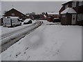
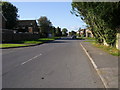
Wren Road, Prestwood in the snow
Taken earlier today, this photo shows Wren Road looking South towards Lodge Lane following heavy snow. Unfortunately, this road, like other residential roads in Prestwood, hadn't been gritted so making it difficult to drive along it. The postcode of this part of Wren Road is HP16 0SB.
Image: © David Hillas
Taken: 11 Dec 2017
0.14 miles