IMAGES TAKEN NEAR TO
New Road, GREAT MISSENDEN, HP16 0EU
Introduction
This page details the photographs taken nearby to New Road, HP16 0EU by members of the Geograph project.
The Geograph project started in 2005 with the aim of publishing, organising and preserving representative images for every square kilometre of Great Britain, Ireland and the Isle of Man.

There are currently over 7.5m images from over14,400 individuals and you can help contribute to the project by visiting https://www.geograph.org.uk
Image Map
Images are licensed for reuse under creativecommons.org/licenses/by-sa/2.0
Notes
- Clicking on the map will re-center to the selected point.
- The higher the marker number, the further away the image location is from the centre of the postcode.
Image Listing (7 Images Found)
Images are licensed for reuse under creativecommons.org/licenses/by-sa/2.0
Image
Details
Distance
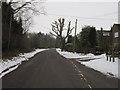
2
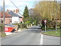
Nag's Head Lane, Little Kingshill
Looking east from the junction with Wychwood Rise.
Image: © Andrew Smith
Taken: 2 Apr 2006
0.14 miles
4
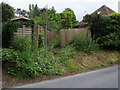
South Bucks Way
The South Bucks Way cuts off Nag's Head Lane up through this alleyway
Image: © Shaun Ferguson
Taken: 30 May 2008
0.16 miles
6
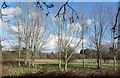
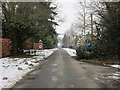
Sunlit Trees at Little Kingshill
A welcome bit of early spring sunshine after a week of snow.
Image: © Des Blenkinsopp
Taken: 7 Mar 2018
0.23 miles
7
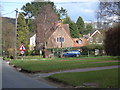
Cottage, Little Kingshill
At the junction of Nag's Head Lane and New Road.
Image: © Andrew Smith
Taken: 2 Apr 2006
0.24 miles