IMAGES TAKEN NEAR TO
Rook Wood Way, GREAT MISSENDEN, HP16 0DF
Introduction
This page details the photographs taken nearby to Rook Wood Way, HP16 0DF by members of the Geograph project.
The Geograph project started in 2005 with the aim of publishing, organising and preserving representative images for every square kilometre of Great Britain, Ireland and the Isle of Man.

There are currently over 7.5m images from over14,400 individuals and you can help contribute to the project by visiting https://www.geograph.org.uk
Image Map
Images are licensed for reuse under creativecommons.org/licenses/by-sa/2.0
Notes
- Clicking on the map will re-center to the selected point.
- The higher the marker number, the further away the image location is from the centre of the postcode.
Image Listing (16 Images Found)
Images are licensed for reuse under creativecommons.org/licenses/by-sa/2.0
Image
Details
Distance
1
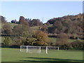
Goal nets - towards Abbey Park
Point where the South Bucks Way approaches, and passes underneath, the railway line.
Image: © Peter S
Taken: 10 Nov 2013
0.13 miles
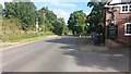
2
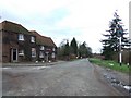
The Nags Head
Looking up London Road towards Great Missenden
Image: © Martyn Davies
Taken: 4 Jan 2007
0.15 miles
3
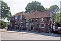
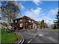
The Nag's Head Public House
Two 18th C. cottages were merged to form this very nice pub. It is Grade II listed, with English Heritage Building ID: 44473. It also has good beer and tasty food.
Image: © Stuart Logan
Taken: 30 Jul 2014
0.16 miles
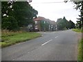
5
Navigating northwards up the Bashire (66)
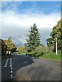
Junction of Nags Head Lane and London Road
Image: © Basher Eyre
Taken: 29 Oct 2024
0.17 miles
8
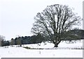
Abbey Park in the snow
Looking north along the River Misbourne towards the trees of the grounds of Missenden Abbey.
Image: © Simon Mortimer
Taken: 24 Jan 2013
0.18 miles
9
London Road
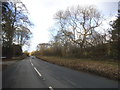
London Road passing the Nags Head
Image: © Shaun Ferguson
Taken: 22 Jul 2020
0.20 miles
10
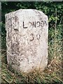
Old Milestone by the A413 in Abbey Park
Carved stone post by the A413, in parish of Great Missenden (Chiltern District), Missenden by-pass, North of Bank's Pond, beside Wendover Woods, in uncut area of grass verge between road and bank of bushes, on East side of road. Amersham limestone square, erected by the Wendover & Oak Lane turnpike trust in the 18th century.
Inscription reads:-
LONDON
30
Carved benchmark on mid left side.
Buckinghamshire HER.
HER Number: 1420400000 https://www.heritagegateway.org.uk/Gateway/Results_Single.aspx?uid=MBC32760&resourceID=1024
Milestone Society National ID: BU_LC30
Image: © A Rosevear & J Higgins
Taken: 21 Aug 2003
0.22 miles