IMAGES TAKEN NEAR TO
St. Johns Road, HIGH WYCOMBE, HP15 7QR
Introduction
This page details the photographs taken nearby to St. Johns Road, HP15 7QR by members of the Geograph project.
The Geograph project started in 2005 with the aim of publishing, organising and preserving representative images for every square kilometre of Great Britain, Ireland and the Isle of Man.

There are currently over 7.5m images from over14,400 individuals and you can help contribute to the project by visiting https://www.geograph.org.uk
Image Map (Loading...)


Getting Data...Please wait
Leaflet Map data © OpenStreetMap
Images are licensed for reuse under creativecommons.org/licenses/by-sa/2.0
Notes
- Clicking on the map will re-center to the selected point.
- The higher the marker number, the further away the image location is from the centre of the postcode.
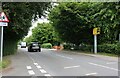
Image Listing (6 Images Found)
Images are licensed for reuse under creativecommons.org/licenses/by-sa/2.0
Image
Details
Distance
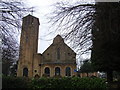
2

Holy Trinity Church car park, Hazlemere
Image: © David Howard
Taken: 24 Jun 2021
0.18 miles
4
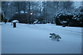
Magnolia Dene, Hazlemere
Snow in 2009
Image: © Veronica Bartyla
Taken: 5 Feb 2009
0.22 miles
5
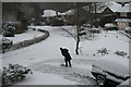
Magnolia Dene, Hazlemere
2010 Snowtime!
Image: © Veronica Bartyla
Taken: 12 Jan 2009
0.22 miles
6
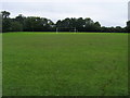
Football pitch
Football pitch on Hazlemere Recreation Ground
Image: © Shaun Ferguson
Taken: 7 Sep 2008
0.24 miles