IMAGES TAKEN NEAR TO
Rose Avenue, HIGH WYCOMBE, HP15 7PQ
Introduction
This page details the photographs taken nearby to Rose Avenue, HP15 7PQ by members of the Geograph project.
The Geograph project started in 2005 with the aim of publishing, organising and preserving representative images for every square kilometre of Great Britain, Ireland and the Isle of Man.

There are currently over 7.5m images from over14,400 individuals and you can help contribute to the project by visiting https://www.geograph.org.uk
Image Map (6 Images)


Getting Data...Please wait
Leaflet Map data © OpenStreetMap
Images are licensed for reuse under creativecommons.org/licenses/by-sa/2.0
Notes
- Clicking on the map will re-center to the selected point.
- The higher the marker number, the further away the image location is from the centre of the postcode.
Image Listing (6 Images Found)
Images are licensed for reuse under creativecommons.org/licenses/by-sa/2.0
Image
Details
Distance
1
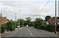
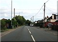
Navigating northwards up the Bashire (60)
Autumn in Old Kiln Road
Image: © Basher Eyre
Taken: 29 Oct 2024
0.13 miles
2
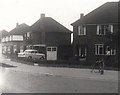
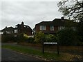
Corner of Old Kiln Road and Ashley Drive, Tylers Green (1962)
Image: © Stanley Howe
Taken: Unknown
0.14 miles
3
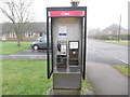
Former KX200 Telephone Kiosk in Tylers Green
Situated in Coppice Farm Road HP10 8AN, this telephone kiosk has a BT notice above the payphone mentioning that it will shortly be removed due to lack of usage. Update: the telephone kiosk has since been removed from this location.
Image: © David Hillas
Taken: 31 Jan 2017
0.16 miles
5
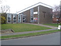
Tylers Green Methodist Church
Situated in Coppice Farm Road HP10 8AH, this Church was officially opened on Saturday 10th August 1968 and is one of twelve churches in the High Wycombe Methodist Circuit. Services are held here every Sunday at 10.45am with various activities taking place during the week.
Image: © David Hillas
Taken: 18 Mar 2014
0.22 miles