IMAGES TAKEN NEAR TO
Sanctuary Road, HIGH WYCOMBE, HP15 7JS
Introduction
This page details the photographs taken nearby to Sanctuary Road, HP15 7JS by members of the Geograph project.
The Geograph project started in 2005 with the aim of publishing, organising and preserving representative images for every square kilometre of Great Britain, Ireland and the Isle of Man.

There are currently over 7.5m images from over14,400 individuals and you can help contribute to the project by visiting https://www.geograph.org.uk
Image Map (Loading...)


Getting Data...Please wait
Leaflet Map data © OpenStreetMap
Images are licensed for reuse under creativecommons.org/licenses/by-sa/2.0
Notes
- Clicking on the map will re-center to the selected point.
- The higher the marker number, the further away the image location is from the centre of the postcode.
Image Listing (3 Images Found)
Images are licensed for reuse under creativecommons.org/licenses/by-sa/2.0
Image
Details
Distance
1
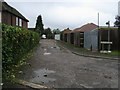
Footpath down Orchard End
Footpath down Orchard End off Sawpit hill
Image: © Shaun Ferguson
Taken: 7 Sep 2008
0.19 miles
3
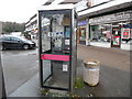
Former KX100 Telephone Box at Hazlemere Park Parade
Situated at Hazlemere Park Parade HP15 7AA, this telephone box has a BT notice indicating that it will soon be removed due to lack of usage. The former BT Piper logo can be seen on the door whilst a "No Smoking" notice is below the payphone. Update: the telephone box has since been removed from this location.
Image: © David Hillas
Taken: 9 Jan 2017
0.24 miles